By Location
By Species
What's In Season by Species
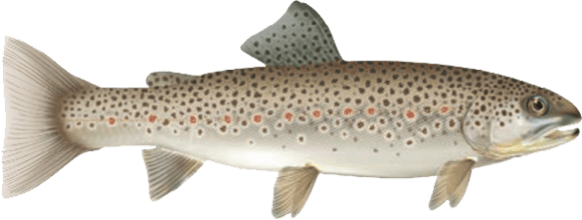
Showing all regulations for Brown Trout.
- Not in Season
- Open in Limited Locations
- Open Season
Show All
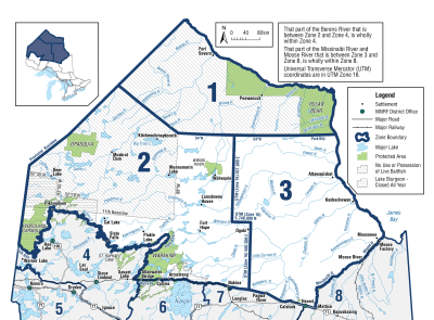
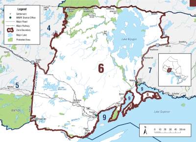
Zone 1

Season Start Date
Season End Date
Closed to fishing
Closed to fishing
Not present in this Zone and are closed to fishing all year
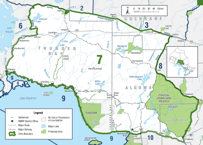
Zone 2
Season Start Date
Season End Date
Sport Limit
5
Conservation Limit
2
Total daily catch and possession limit for all trout and salmon species combined
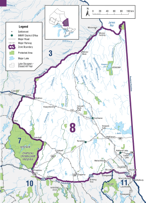
Zone 3

Season Start Date
Season End Date
Closed to fishing
Closed to fishing
Not present in this Zone and are closed to fishing all year
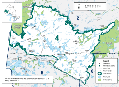
Zone 4
Season Start Date
Season End Date
Closed to fishing
Closed to fishing
Not present in this Zone and are closed to fishing all year
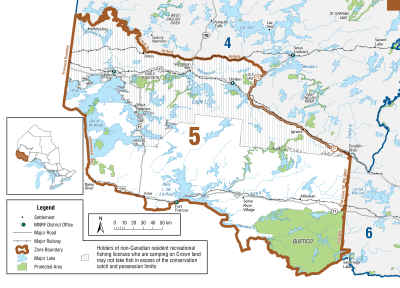
Zone 5
Season Start Date
Season End Date
Sport Limit
5
Conservation Limit
2
Total daily catch and possession limit for all trout, salmon and splake species combined
Zone 6
Season Start Date
Season End Date
Sport Limit
5
Conservation Limit
2
Total daily catch and possession limit for all trout, salmon and splake species combined
Zone 7
Season Start Date
Season End Date
Sport Limit
5
Conservation Limit
2
Total daily catch and possession limit for all trout, salmon and splake species combined
Zone 8
Season Start Date
Season End Date
Closed to fishing
Closed to fishing
Not present in this Zone and are closed to fishing all year
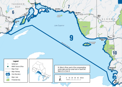
Zone 9
Season Start Date
Season End Date
Sport Limit
5
Conservation Limit
2
Total daily catch and possession limit for all trout, salmon and splake species combined
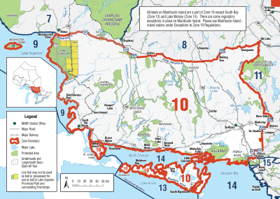
Zone 10
Season Start Date
Season End Date
Sport Limit
5
Conservation Limit
2
Total daily catch and possession limit for all trout, salmon and splake species combined
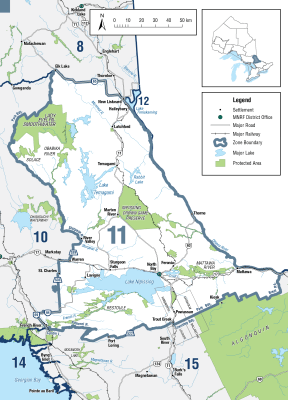
Zone 11
Season Start Date
Season End Date
Sport Limit
5
Conservation Limit
2
Total daily catch and possession limit for all trout, salmon and splake species combined
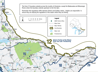
Zone 12
Season Start Date
Season End Date
Sport Limit
5
Conservation Limit
2
Total daily catch and possession limit for all trout, salmon and splake species combined
Zone 13

Season Start Date
Season End Date
Sport Limit
5
Conservation Limit
2
Total daily catch and possession limit for all trout, salmon and splake species combined
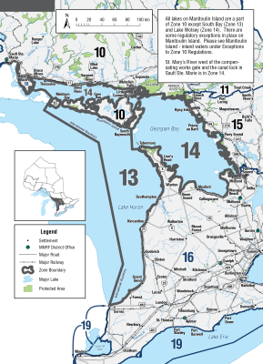
Zone 14
Season Start Date
Season End Date
Sport Limit
5
Conservation Limit
2
Total daily catch and possession limit for all trout, salmon and splake species combined
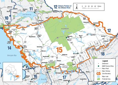
Zone 15
Season Start Date
Season End Date
Sport Limit
5
Conservation Limit
2
Total daily catch and possession limit for all trout, salmon and splake species combined
Zone 16
Season Start Date
Season End Date
Sport Limit
5
Conservation Limit
2
Total daily catch and possession limit for all trout, salmon and splake species combined
Additional Fishing Opportunities
Season Start Date
Season End Date
Sport Limit
5
Conservation Limit
2
Additional fishing opportunities
- Big Creek - Walsingham Township, downstream from Regional Road 21 to Long Point Bay of Lake Erie
- North Thames River (main branch only) - Middlesex County
- Black Creek - City of Nanticoke, from Highway 3 to the junction with the Lynn River
- Bronte Creek - Town of Oakville, from Highway 2 (Lakeshore Road West) to Lake Ontario
- Credit River and tributaries - City of Mississauga, from the south side of Highway 403 bridge downstream to Lake Ontario
- Don River and tributaries - City of Toronto, from Lake Ontario upstream to Eglinton Avenue
- Fifteen Mile Creek - City of St. Catharines and Town of Lincoln, between the Queen Elizabeth Way and Lake Ontario
- Forty Mile Creek - Town of Grimsby, between the Queen Elizabeth Way and Lake Ontario
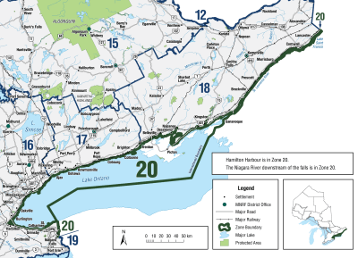
- Grindstone Creek - City of Burlington, from Highway 2 (Plains Road) to Hamilton Harbour of Lake Ontario (City of Hamilton in the Region of Halton)
- Highland Creek - City of Toronto from the downstream edge of the Highway 2 (Kingston Road) bridge to Lake Ontario
- Humber River - City of Toronto, between Eglinton Avenue and Lake Ontario
- Nottawasaga River - from the Boyne River downstream (north) to Georgian Bay
- Rouge River - City of Toronto, between Highway 2 (Kingston Road) and Lake Ontario
- Sixteen Mile Creek (Oakville Creek) - Town of Oakville, from Highway 2 (Lakeshore Road) to Lake Ontario
- Sixteen Mile Creek - Town of Lincoln, between the Queen Elizabeth Way and Lake Ontario
- Spencer Creek - City of Hamilton, from Highway 102 (Cootes Drive) to Lake Ontario
- Thames River - Elgin County and Middlesex County and the Municipality of Chatham-Kent, main branch only
- Trout Pond of Waterford Ponds - City of Nanticoke
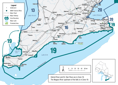
- Twelve Mile Creek (Zone 20) - City of St. Catharines, between Lakeport Road and Lake Ontario
- Twenty Mile Creek - Town of Lincoln, between the Queen Elizabeth Way and Lake Ontario
- Young’s Creek (Ryerse Creek) - Woodhouse Township, from the downstream side of the Front Road bridge to Lake Erie at Port Ryerse
Total daily catch and possession limit for all trout, salmon and splake species combined
Additional Fishing Opportunities
Season Start Date
Season End Date
Sport Limit
5
Conservation Limit
2
Additional fishing opportunities
- Bayfield River - Goderich and Stanley Townships, from Highway 4 to the downstream side of the Highway 21 bridge (Huron County)
- Beaver River - Collingwood Township, from the Thornbury Dam to Georgian Bay (Grey County)
- Big Creek - Walsingham Township, south of the Quance Dam to Regional Road 21 at Lynedoch
- Big Otter Creek - Bayham Township (Elgin County)
- Bighead River - St. Vincent Township (Grey County)
- Bronte Creek - Town of Oakville from Highway 2 (Lakeshore Road West) upstream to the south side of Highway 407
- Credit River and tributaries - from the south side of Britannia Road in the City of Mississauga upstream to the south side of the Highway 407 Bridge in the City of Brampton
- Don River and tributaries - upstream from Eglinton Avenue in the City of Toronto to the south side of Highway 407 in the Regional Municipality of York
- Grand River - from a line across the Grand River in Paris at 100 m downstream of the Highway 2 (Dundas Street West) bridge to the edge of Lake Erie (see waterbody exceptions for catch and possession limits)
- Hog Creek - Tay Township from the C.P.R. bridge (Lot 10, Concession 6) downstream (north) to Georgian Bay (Simcoe County)
- Humber River and tributaries - upstream from Eglinton Avenue in the City of Toronto to the south side of the Highway 407 bridge in the Regional Municipality of York
- Little Otter Creek - Bayham Township, East branch of Big Otter Creek
- Little Sauble River - Bruce Township, from Highway 21 to Lake Huron (Bruce County)
- Maitland River - Colborne, Goderich, Hullett, East and West Wawanosh and Turnberry Townships, between County Road 4 and the downstream side of the Highway 21 bridge (Huron County)
- Nine Mile River (Lucknow River) - Ashfield and West Wawanosh Townships, between County Road 86 and Lake Huron
- North Creek - Middleton Township, downstream of Highway 3
- Rouge River - from Highway 2 (Kingston Road) in the City of Toronto upstream to the south side of Highway 407 in the Town of Markham
- Sauble River - Amabel Township, from the lowest ledge of Sauble Falls 440 m downstream to a line drawn perpendicular to the river’s current
- Saugeen River - Arran, Amabel, Brant, Elderslie and Saugeen Townships and in the Town of Walkerton and the Village of Paisley, between the southerly edge of the Municipality of Brockton Concession 2 SDR. bridge and the westerly edge of the concrete abutments downstream of Denny’s Dam
- Sixteen Mile Creek (Oakville Creek) and tributaries - Town of Oakville from Highway 2 (Lakeshore Road) upstream to the south side of Highway 407
- Sturgeon River and tributaries - Tay and Oro-Medonte Townships (Simcoe County), including the mouth of the Sturgeon River at Georgian Bay
- Young’s Creek - from the dam on Lot 23, Concession 3 to the downstream side of the Front Road bridge
Total daily catch and possession limit for all trout, salmon and splake species combined
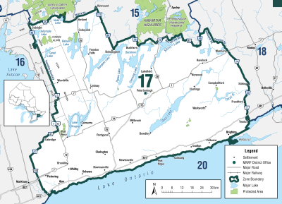
Zone 17
Season Start Date
Season End Date
Sport Limit
5
Conservation Limit
2
Total daily catch and possession limit for all trout, salmon and splake species combined
Additional Fishing Opportunities
Season Start Date
Season End Date
Sport Limit
5
Conservation Limit
2
Additional fishing opportunities
- Cobourg Brook (Cobourg Creek or Factory Creek) - between the southerly limit of the C.N.R. right-of-way and Lake Ontario
- Gages Creek - between the southerly limit of the C.N.R. right-of-way and Lake Ontario
- Ganaraska River - between the southerly limit of the C.N.R. right-of-way and Lake Ontario
- Regional Municipality of Durham - all waters lying between the southerly limit of the C.N.R. right-of-way and Lake Ontario
Total daily catch and possession limit for all trout, salmon and splake species combined
Additional Fishing Opportunities
Season Start Date
Season End Date
Sport Limit
5
Conservation Limit
2
Additional fishing opportunities
- Northumberland County - all waters downstream of Highway 2, except the Ganaraska River which may only be fished downstream of the south side of the C.P.R. bridge
- Regional Municipality of Durham - all waters between Highway 2 and the southerly limit of the C.N.R. right-of-way
Total daily catch and possession limit for all trout, salmon and splake species combined
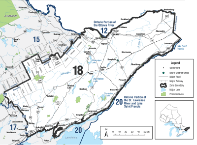
Zone 18
Season Start Date
Season End Date
Sport Limit
5
Conservation Limit
2
Total daily catch and possession limit for all trout, salmon and splake species combined
Zone 19
Season Start Date
Season End Date
Sport Limit
5
Conservation Limit
2
Total daily catch and possession limit for all trout, salmon and splake species combined
Zone 20
Season Start Date
Season End Date
Sport Limit
5
Conservation Limit
2
Total daily catch and possession limit for all trout, salmon and splake species combined
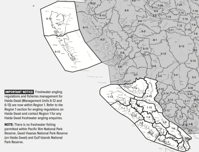
Region 1
Season Start Date
Season End Date
Limit
4
Not more than
- 1 over 50 cm
- 2 from streams (must be hatchery)
And you must release:
- All wild trout from streams
NOTE: There is no general minimum size limit for trout in lakes or hatchery origin trout in streams.
Total daily catch of 4 for all trout/char species combined
Additional Fishing Opportunities
Season Start Date
Season End Date
Limit
5
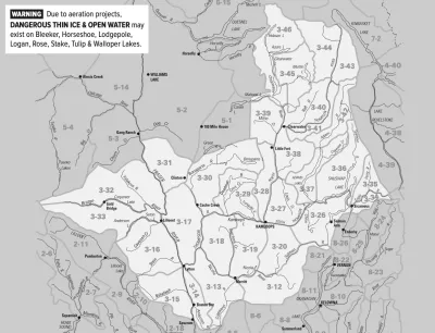
Haida Gwaii Daily Quotas
Not more than
- 1 over 50 cm
- 2 from streams
And you must release:
- Trout from streams under 30 cm
Total daily catch of 5 for all trout/char species combined
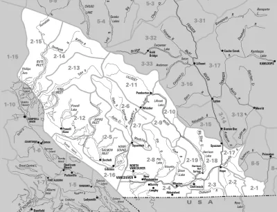
Region 2
Season Start Date
Season End Date
Limit
4
Not more than
- 1 over 50 cm
- 2 from streams (must be hatchery)
And you must release:
- Wild trout/char from streams
- Hatchery trout/char under 30 cm from streams
NOTE: There is no general minimum size limit for trout in lakes.
Total daily catch of 4 for all trout/char species combined
Region 3
Season Start Date
Season End Date
Limit
5
Not more than
- 4 from streams
- 1 over 50 cm
Total daily catch of 5 for all trout/char species combined
Region 4
Season Start Date
Season End Date
Limit
5
but not more than
- 2 from streams
Total daily catch of 5 for all trout/char species combined
Region 5
Season Start Date
Season End Date
Limit
5
but not more than
- 1 over 50 cm
- 2 from streams
Total daily catch of 5 for all trout/char species combined
Region 6
Season Start Date
Season End Date
Limit
5
Not more than
- 1 over 50 cm
- 1 from streams Jul 1 - Oct 31
And you must release
- Trout under 30 cm from any stream
- Trout of any size from streams Nov 1 - June 30
Total daily catch of 5 for all trout/char species combined
Region 7A
Season Start Date
Season End Date
Limit
5
Not more than
- 1 over 50 cm
- 2 from streams
Total daily catch of 5 for all trout/char species combined
Region 7B
Season Start Date
Season End Date
Limit
5
but not more than
- 1 over 50 cm
- 2 from streams
Total daily catch of 5 for all trout/char species combined
Region 8
Season Start Date
Season End Date
Limit
5
but not more than
- 1 over 50 cm
- 4 from streams (only 2 over 30 cm)
Total daily catch of 5 for all trout/char species combined
Copyright © 2026 What To Fish. All Rights Reserved.
Site by Sage
Solutions