By Location
By Species
What's In Season by Species
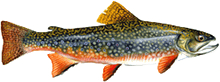
Showing all regulations for Brook Trout.
- Not in Season
- Open in Limited Locations
- Open Season
Show All
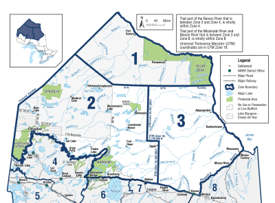
Zone 1

Season Start Date
Season End Date
Sport Limit
5
Conservation Limit
2
not more than 1 greater than 40 cm ( 15 3/4" )
Total daily catch and possession limit for all trout and salmon species combined
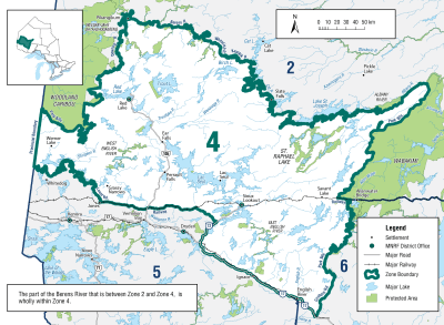
Zone 2
Season Start Date
Season End Date
Sport Limit
5
Conservation Limit
2
not more than 1 greater than 30 cm ( 11 3/4" )
Total daily catch and possession limit for all trout and salmon species combined
Additional Fishing Opportunities
Season Start Date
Season End Date
Sport Limit
5
Conservation Limit
2
Additional Fishing Opportunities
no size limit
- Blue Lake (50°20’04”N., 88°56’56”W.)
- Johnny Lake (50°17’35”N., 87°02’52”W.) - Rupert Township
- Secret Lake (50°18’53”N., 88°58’29”W.)
- Unnamed Lake (Whiz Lake) (51°38’11”N., 89°58’01”W.
Total daily catch and possession limit for all trout and salmon species combined
Zone 3

Additional Fishing Opportunities
Season Start Date
Season End Date
Sport Limit
5
Conservation Limit
2
Additional Fishing Opportunities
- Pelican Lake (49°54’41”N., 84°08’09”W.) - Rogers Township
- Scaup Lake (50°01’58”N., 84°09’01”W.) - Area 238
Total daily catch and possession limit for all trout, salmon and splake species combined
Season Start Date
Season End Date
Sport Limit
5
Conservation Limit
2
Total daily catch and possession limit for all trout, salmon and splake species combined
Zone 4
Additional Fishing Opportunities
Season Start Date
Season End Date
Sport Limit
5
Conservation Limit
2
Additional Fishing Opportunities
no size limit
- Berglund Lake (49°35’50”N., 91°38’27”W.)
- Bill Lake (50°04’02”N., 93°58’07”W.)
- Butler Lake (49°29’10”N., 91°50’13”W.) - Bradshaw Township
- Dog Lake (50°00’51”N., 94°00’49”W.)
- Highway Lake (50°04’16”N., 92°01’30”W.) - Drayton Township
- Krisko Lake (49°42’33”N., 91°12’60”W.)
- Little Butler Lake (49°28’41”N., 91°50’29”W.) - Bradshaw Township
- Little Snowstorm Lake (49°37’26”N., 91°43’06”W.)
- McLaurin Lake (49°43’13”N., 91°12’05”W.)
- Nyilas Lake (50°03’57”N., 92°04’20”W.) - Drayton Township
- O’Dell Lake (49°24’01”N., 91°35’10”W.) - Skey Township
- Reguly Lake (49°38’01”N., 91°43’40”W.)
- Shrimp Lake (49°35’26”N., 91°38’55”W.)
- Snowstorm Lake (49°37’17”N., 91°43’27”W.)
- Snyder Lake (50°03’52”N., 92°04’40”W.) - Drayton Township
- Wreck Lake (50°02’50”N., 94°08’13”W.)
Total daily catch and possession limit for all trout, salmon and splake species combined
Season Start Date
Season End Date
Sport Limit
5
Conservation Limit
2
not more than 1 greater than 30 cm ( 11 3/4" )
Total daily catch and possession limit for all trout, salmon and splake species combined
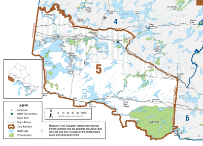
Zone 5
Season Start Date
Season End Date
Sport Limit
5
Conservation Limit
2
Total daily catch and possession limit for all trout, salmon and splake species combined
Zone 6
Season Start Date
Season End Date
Sport Limit
5
Conservation Limit
2
not more than 1 greater than 30 cm ( 12" ). No size limit in some areas
Total daily catch and possession limit for all trout, salmon and splake species combined
Additional Fishing Opportunities
Season Start Date
Season End Date
Sport Limit
1
Conservation Limit
0
must be greater than 56 cm
All tributaries to Lake Superior in Zone 6 described as follows:
- Current River downstream from the Boulevard Lake Dam (48°27′N., 89°11′W.);
- Coldwater Creek downstream from Ouimet Canyon Road (48°45′N., 88°36′W.);
- Spring Creek downstream from Dorion Fish Culture Station (48°50′N., 88°36′W.);
- Wolf River downstream from the lower falls (48°50′58″N., 88°34′87″W.);
- Black Sturgeon River downstream from the dam (48°55′N., 88°23′W.);
- Nipigon River, entire length including Jessie Lake, Polly Lake and Lake Helen;
- From the Pigeon River to the Nipigon River, all tributaries lying downstream from Highway 61 and Highway 11/17, including Sibley and Black Bay Peninsula and all islands and excluding those listed in the first six sub-bullets above.
Additional Fishing Opportunities
Season Start Date
Season End Date
Sport Limit
5
Conservation Limit
2
- Adrian Lake (48°27′10″N, 89°48′58″W)
- Aldina Lake (48°21′31″N, 89°58′41″W)
- Annette Lake (49°26′06″N, 89°39′49″W)
- Bateman Lake (48°30′33″N, 89°45′17″W)
- Bell Lake (48°06′16″N, 89°42′26″W)
- Birch Lake (48°10′28″N, 90°07′18″W)
- Blake’s Lake (48°56′57″N, 88°28′11″W)
- Caribou Lake (48°37′23″N, 88°40′14″W)
- Caro Lake (49°06′13″N, 88°57′50″W)
- Cavern Lake (48°50′04″N, 88°39′35″W)
- Chub Lake (48°16′54″N, 89°34′22″W)
- Deer Lake (49°03′36″N, 88°20′23″W)
- Devon Lake (48°09′18″N, 89°50′45″W)
- Devonline Lake (48°09′33″N, 89°50′58″W)
- Downy Lake (48°14′23″N, 89°52′10″W)
- Duchess Lake (Dutchies Lake) (48°52′26″N, 88°34′18″W)
- Echo Lake (48°19′30″N, 89°53′33″W)
- Elbow Lake (48°10′56″N, 90°16′23″W)
- Fall Lake (48°47′51″N, 88°38′02″W)
- Five Minute Lake (48°40′28″N, 88°48′04″W)
- Float Lake (48°20′37″N, 89°53′20″W)
- Forrest Lake (48°07′24″N, 90°15′14″W)
- Furcate Lake (48°47′11″N, 88°45′50″W)
- Goddard Lake (49°42′22″N, 87°43′38″W)
- Gold Lake (48°30′05″N, 89°45′08″W)
- Golding Lake (48°35′49″N, 89°14′00″W)
- Goodmorning Lakes North (48°47'11″N, 88°42'03″W)
- Goodmorning Lakes South (48°46'41″N, 88°41'47″W)
- Grande Lake (48°49′09″N, 88°40′52″W)
- Hans’ Lake (McMaster Lake 79) (49°01′53″N, 88°35′04″W)
- Hartington Lake 1 (48°09′04″N, 89°56′37″W) – Hartington Township
- Hartington Lake 2 (48°08′32″N, 89°57′18″W) – Hartington Township
- Hartington Lake 3 (48°08′49″N, 89°56′57″W) – Hartington Township
- Head Lake (48°16′50″N, 90°09′30″W)
- Himdick Lake (48°45′22″N, 88°43′30″W)
- Inwood Lake (49°01′10″N, 90°26′45″W)
- Jeff Lake (48°43′14″N, 88°39′58″W)
- Joan Lake (48°06′19″N, 89°43′38″W)
- Lauries Lakes 1 (48°15′01″N, 90°16′32″W)
- Lauries Lake 3 (Larrys Lake 3) (48°14′16″N, 90°17′18″W)
- Lauries Lake 4 (Larrys Lake 4) (48°14′30″N, 90°17′16″W)
- Lismore Lake 1 (48°09′28″N, 89°56′42″W)
- Lismore Lake 2 (48°09′21″N, 89°57′06″W)
- Little Addie Lake (48°09′18″N, 90°25′02″W)
- Little Hawkeye Lake (48°40′08″N, 89°27′40″W)
- Little Head Lake (48°16′20″N, 90°08′21″W)
- Liver Lake (48°36′33″N, 88°56′28″W)
- Lizard Lake (48°14′33″N, 89°52′23″W)
- Loch Muich Lake (48°36′14″N, 90°20′39″W)
- Lofquist Lake (49°02′18″N, 88°20′21″W)
- Lorne’s Lake (49°03′47″N, 88°35′57″W)
- Lower Moonshine Lake (48°52′25″N, 88°35′59″W)
- Malborne Lake (49°11′52″N, 88°25′15″W)
- Male Lake (49°13′11″N, 88°22′33″W)
- Matson Lake (48°05′48″N, 89°42′04″W)
- McKecknie Lake (48°07′25″N, 90°14′21″W)
- Middle Moonshine Lake (48°52′39″N, 88°36′04″W)
- Moonshine Lake (48°52′53″N, 88°36′12″W)
- Morrison Lake (48°11′09″N, 89°52′44″W)
- Mutt Lake (48°43′25″N, 88°40′09″W)
- No Good Lake (49°03′00″N, 88°21′00″W)
- Nunya Lake (49°28'59″N, 89°35'27″W)
- Paradise Lake (48°40′55″N, 88°48′20″W)
- Peridotite Lake (48°29′34″N, 89°46′50″W)
- Peter’s Lake (48°57′13″N, 88°28′58″W)
- Pocket Lake (48°52′19″N, 88°40′39″W)
- Ranger Lake (48°23′16″N, 89°52′10″W)
- Rock Lake (48°11′13″N, 90°05′29″W)
- Roll Lake (Lake 19) (48°38′30″N, 88°57′37″W)
- Sand Lake North (48°15′18″N, 90°14′25″W)
- Scott Lake 1 (48°10′51″N, 90°18′47″W)
- Scott Lake 2 (48°10′41″N, 90°17′49″W)
- Shale Lake (48°53′36″N, 88°43′16″W)
- Shoepac Lake (49°00′50″N, 88°22′47″W)
- Sitches Lake (48°39′24″N, 90°38′27″W)
- South Fallingsnow East Lake (48°08′21″N, 89°47′46″W)
- South Fallingsnow West Lake (48°08′33″N, 89°48′00″W)
- Stillwater Lake (49°02′07″N, 88°24′17″W)
- Sunset Lake (48°44′19″N, 88°40′55″W)
- Sunset Lake (48°12′11″N, 89°56′20″W)
- Tear Drop Lake (48°37′17″N, 90°21′60″W)
- Ten Minute Lake (48°22′38″N, 89°52′14″W)
- Thompson Lake (48°52′52″N, 88°34′42″W)
- Thompson Lake 2 (48°17′37″N, 89°35′06″W)
- Thunder Lake (48°29′55″N, 89°45′55″W)
- Tuesday Lake (48°44′15″N, 89°05′16″W)
- Twin Mountain Lake (48°10′47″N, 89°49′33″W)
- Unnamed Lake 9 (49°02′12″N, 88°28′20″W)
- Unnamed Lake 19 (49°02′11″N, 88°26′23″W)
- Unnamed Lake 20 (49°00′31″N, 88°28′44″W)
- Unnamed Lake 21 (49°00′03″N, 88°28′08″W)
- Unnamed Lake 22 (48°58′05″N, 88°32′09″W)
- Unnamed Lake 34 (49°01′55″N, 88°25′13″W)
- Unnamed Lake 39 (48°56′32″N, 88°25′45″W)
- Wasp Lake (48°13′31″N, 90°11′12″W)
- West Arrow Lake (48°07′35″N, 90°26′13″W)
- West Greenhue Lake (48°42′01″N, 89°27′03″W)
- West MacDonald Lake (48°50′16″N, 88°38′45″W)
Zone 7
Additional Fishing Opportunities
Season Start Date
Season End Date
Sport Limit
2
Conservation Limit
1
No size limit
- Buckaday Lake (48°58′52″N., 87°45′06″W.) - including headwaters lakes
- Macutagon Ponds (49°07′24″N., 85°37′19″W.) - Cecil Township
- All waters in the Townships of Broughton, Atkinson, Cooper, Doucette, Nameigos, McGowan and Mosambik
- Missing Lake (48°00′07″N., 85°29′08″W.)
- Waters east of Pukaskwa National Park - within the following boundary: beginning at the southwest corner of Legarde Township, then west along the projection of the southeast boundary of Legarde Township, to the east boundary of Pukaskwa National Park, then northerly along the Park Boundary to the northeast corner of Pukaskwa National Park, then in a straight line easterly to the northwest corner of Memaskwash Township, then east along the north boundary of Memaskwash Township, then south along the east boundary of Memaskwash Township and Charbonneau Township, then west along the south boundary of Charbonneau Township, then south along the east boundary of Keating Additional and Legarde Additional to the beginning; and including the waters of Little Beaver Lake (48°14′13″N., 85°19′19″W.), Coronation Creek, Coronation Lake (48°15′57″N., 85°18′51″W.) and their tributaries in Keating Township; and the tributaries of Farewell Creek in Legarde Township; but not including the waters of East Pukaskwa Lake (48°06'12″N., 85°37'00"W.)
Total daily catch and possession limit for all trout, salmon and splake species combined
Additional Fishing Opportunities
Season Start Date
Season End Date
Sport Limit
1
Conservation Limit
0
must be greater than 56 cm
- All tributaries to Lake Superior in Zone 7 described as follows:
- Jackfish River - downstream from the falls (49°03′N., 88°06′W.)
- Jackpine River - downstream from Wilson’s Falls (49°07′N., 87°53′W.)
- Cypress River - downstream from falls (48°57′N., 87°50′W.)
- Cypress River - west tributary downstream from the falls (48°57′N., 87°51′W.)
- Gravel River - downstream from the falls (48°55′26″N., 87°41′46″W.)
- Little Gravel River - downstream from the falls (48°56′01″N., 87°46′36″W.)
- Steel River - downstream from the Golden Staircase (outflow of Santoy Lake)
- McKellar River - downstream from the falls 150 metres north of Highway 17
- Prairie River - downstream from the first hydro line north of Lake Superior
- From the east shore of the Nipigon River to Camp 81 Road, all tributaries lying downstream from Highway 17, excluding those listed in the first nine sub-bullets above
- From Camp 81 Road east to the Whitesand River (48°50′N., 87°24′W.), all tributaries lying downstream from the first hydro line north of Lake Superior, excluding those listed in the first nine sub-bullets above
- From and including the Whitesand River to the west shore of the Pic River all tributaries lying downstream from Highway 17, excluding those listed in the first nine sub-bullets above
- All tributaries to Lake Superior in Zone 7 from the Pic River to the Michipicoten River, inclusive, downstream from the first falls, rapids, dam or lake or the entire tributary if there are no falls, rapids, dams or lakes
Total daily catch and possession limit for all trout, salmon and splake species combined
Season Start Date
Season End Date
Sport Limit
5
Conservation Limit
2
Sport Limit: not more than 2 greater than 30 cm ( 12" ), of which not more than 1 greater than 40 cm ( 15 3/4" )
Conservation Limit: not more than 1 greater than 30 cm ( 12" ), of which none greater than 40 cm ( 15 3/4" )
Total daily catch and possession limit for all trout, salmon and splake species combined
Additional Fishing Opportunities
Season Start Date
Season End Date
Sport Limit
5
Conservation Limit
2
No size limit
- Ambrose Lake (48°54′58″N., 87°21′46″W.)
- Angel Lake (48°46′02″N., 86°52′10″W.) - Tuuri Township
- Arnott 19 (49°35′26″N., 84°39′33″W.) - Arnott Township
- Ashmore Lake (48°51′50″N., 87°11′09″W.) - Priske Township
- Atkinson Lake 1 (48°31′07″N., 84°45′55″W.) - Atkinson Township
- Ault Lake (48°57′56″N., 87°37′32″W.) - Yesno Township
- Belanger Lake (49°07′47″N., 84°36′12″W.) - Lascelles Township
- Bews Lake (48°51′31″N., 87°03′18″W.) - Strey Township
- Big Lake (48°09′50″N., 84°30′04″W.) - Cowie Township
- Bittern Lake (48°27′35″N., 83°15′07″W.) - Lerwick Township
- Bluebill Lake (48°56′37″N., 87°40′23″W.) - Yesno Township
- Bluff Lake (48°57′21″N., 87°14′58″W.)
- Bob Lake (49°22′23″N., 85°51′13″W.)
- Boobus Lake (49°28′14″N., 87°09′19″W.)
- Botham Lake (48°41′44″N., 85°58′08″W.) - Bomby Township
- Buck Lake (48°38′28″N., 85°23′21″W.) - Cecile Township
- Cantin Lake (49°37′20″N., 84°37′02″W.) - Arnott Township
- Centennial Lake (47°54′51″N., 84°42′51″W.) - Naveau Township
- Chain Lake (49°26′03″N., 85°49′44″W.)
- Chapman Lake (49°04′53″N., 87°18′21″W.)
- Charlotte Lake (48°57′41″N., 87°16′07″W.)
- Claire Lake (49°37′00″N., 84°36′45″W.) - Arnott Township
- Clearwater Lake (48°40′19″N., 85°13′53″W.) - Common Township
- Cruise Lake (48°13′25″N., 84°54′26″W.) - Lalibert Township
- Curry Lakes A (47°55′55″N., 84°03′01″W.) - Recollet Township
- Curry Lakes B (47°55′31″N., 84°03′08″W.) - Recollet Township
- Curry Lakes C (47°55′23″N., 84°03′26″W.) - Recollet Township
- Dead Lake (48°37′40″N., 85°23′10″W.) - Cecile Township
- Deadman Lake (49°25′13″N., 86°15′48″W.)
- Deep Lake (48°56′09″N., 87°15′06″W.)
- Dew Lake (48°49′14″N., 86°58′45″W.) - Syine Township
- Disappointment Lake (48°08′38″N., 84°27′27″W.) - Cowie Township
- Doran Lake (49°06′55″N., 84°37′57″W.) - Larkin Township
- Dragline Lake (48°38′04″N., 85°24′21″W.) - Cecile Township
- Drop Lake (48°49′43″N., 86°59′15″W.) - Syine Township
- Dycie Lake (47°56′11″N., 84°45′28″W.) - McMurray Township
- East Shell Lake (48°27′22″N., 85°07′15″W.) - Vasiloff Township
- Echo Lake (48°47′07″N., 86°54′07″W.) - Syine Township
- Emerald Lake (49°09′09″N., 85°36′17″W.) - Nickle Township
- Emond Lake (49°36′41″N., 84°39′36″W.) - Arnott Township
- Empire Lake (49°36′56″N., 87°56′15″W.) - Summers Township
- Eric Lake (49°36′57″N., 84°38′60″W.) - Arnott Township
- Eric Lake (48°51′11″N., 86°54′56″W.) - Syine Township
- Evelyn Lake (49°37′26″N., 84°36′04″W.) - Arnott Township
- Fire Hill Lake (49°01′20″N., 88°07′40″W.) - Corrigal Township
- Flats Lake (48°56′54″N., 87°40′27″W.) - Yesno Township
- Fog Lake (48°54′40″N., 87°07′40″W.)
- Francoise Lake (48°28′56″N., 84°17′22″W.) - St Julien Township
- Furnival Lake (48°13′04″N., 84°55′40″W.) - Knicely Township
- Gagnon Lake (49°37′36″N., 84°34′45″W.) - Arnott Township
- Gaug Lake (49°08′22″N., 85°51′48″W.) - Leslie Township
- Gordon Lake (48°51′14″N., 86°54′11″W.) - Syine Township
- Haf Lake (48°16′42″N., 84°04′53″W.) - Copenace Township
- Hartley Lake (49°28′43″N., 87°08′40″W.)
- Hilder Lake (49°46′51″N., 86°58′46″W.) - Fulford Township
- Hob Lake (49°30′12″N., 86°30′03″W.)
- Hook Lake (49°33′33″N., 84°37′15″W.) - McEwing Township
- Igloo Lake (47°57′35″N., 83°20′33″W.) - D’Arcy Township
- Jason Lake (48°50′42″N., 87°21′11″W.) - Killraine Township
- Jerrards Lake (48°29′16″N., 85°11′07″W.) - Vasiloff Township
- Jo-Jo Lake (Minnow Lake) (50°10′34″N., 86°46′25″W.) - Exton Township
- Jubilee Lake (47°58′50″N., 84°44′53″W.) - McMurray Township
- Kabossakwa Pothole Lake (48°51′30″N., 85°24′23″W.) - Mikano Township
- Klein Lake (48°56′35″N., 85°15′25″W.) - Welsh Township
- Lake 34 (49°11′17″N., 85°35′50″W.) - Nickle Township
- Lake 35 (49°11′26″N., 85°35′24″W.) - Nickle Township
- Lake 36 (49°10′54″N., 85°36′09″W.) - Nickle Township
- Lake E-11 (50°06′05″N., 86°26′41″W.) - Nettleton Township
- Lamont Lake (48°48′28″N., 87°14′07″W.) - Priske Township
- Lena Lake (Leana Lake) (49°49′56″N., 86°20′47″W.)
- Leo’s Lake (48°33′48″N., 85°12′36″W.) - Hunt Township
- Lewis Lake (49°37′26″N., 84°36′29″W.) - Arnott Township
- Limestone Lake (49°06′40″N., 88°09′40″W.)
- Little Flood Lake (48°45′47″N., 85°24′24″W.) - Flood Township
- Little Hart Lake (49°43′29″N., 84°17′56″W.) - Gill Township
- Little Harvie Lake (49°01′12″N., 87°11′17″W.)
- Lovely Lake (49°07′21″N., 84°36′02″W.) - Lascelles Township
- Lower Ross Lake (48°53′57″N., 87°20′18″W.)
- Manton Lake (48°06′55″N., 84°07′01″W.) - Echum Township
- McAvay Lake (49°18′48″N., 88°06′33″W.)
- Mercury Lake (48°29′18″N., 85°33′23″W.)
- Mickey Lake (48°59′45″N., 85°52′30″W.)
- Middleton Lake (49°30′23″N., 86°29′30″W.)
- Mikano Pothole Lake (48°50′38″N., 85°20′07″W.) - Mikano Township
- Mile 30 Lake (50°05′14″N., 86°28′16″W.) - Raynar Township
- Mileage 10 Pothole Lake (48°29′02″N., 85°09′08″W.) - Chapais Township
- Minnow Lake (48°51′12″N., 87°05′21″W.) - Strey Township
- Minto Lake (47°58′18″N., 84°45′00″W.) - McMurray Township
- Mole Lake (49°33′41″N., 84°34′50″W.) - McEwing Township
- Murphy Lake (49°37′32″N., 84°36′51″W.) - Arnott Township
- Myrtle Lake (49°38′09″N., 84°34′46″W.) - Arnott Township
- Mystery Lake (48°19′42″N., 84°43′30″W.) - Dumas Township
- Nik Lake (48°08′37″N., 84°45′22″W.) - Musquash Township
- Norn Lake (49°07′16″N., 84°37′29″W.) - Larkin Township
- North O’Brien Lake (48°32′30″N., 85°08′25″W.) - Abraham Township
- North Oganek Lake (48°33′55″N., 85°07′46″W.) - Abraham Township
- North Twin Lake (48°38′09″N., 85°23′53″W.) - Cecile Township
- Norwalk Lake (47°55′33″N., 84°44′57″W.) - Rabazo Township
- O’Brien Lake (48°32′41″N., 85°08′13″W.) - Abraham Township
- Other Man’s Lake (49°05′29″N., 84°45′19″W.) - Larkin Township
- Pearkes Lake 10 (48°31′48″N., 84°25′18″W.) - Pearkes Township
- Pointing Lake (49°31′11″N., 84°42′21″W.) - Frost Township
- Post Lake (49°29′48″N., 86°36′06″W.)
- Rice Lake (49°44′46″N., 84°17′15″W.) - Gill Township
- Rod and Gun Lake (47°59′51″N., 84°50′03″W.) - Lendrum Township
- Rootcellar Lake (48°24′38″N., 85°00′08″W.) - Ashley Township
- Rope Lake (49°02′21″N., 87°19′30″W.)
- Sand Lake (49°07′32″N., 85°54′02″W.) - Leslie Township
- Setting Duck Lake (49°40′49″N., 87°32′53″W.) - Leduc Township
- Shaw Lake (49°07′34″N., 84°36′47″W.) - Larkin Township
- Sider Lake (49°37′01″N., 84°35′07″W.) - Arnott Township
- Slim Lake (49°34′15″N., 84°40′44″W.) - McEwing Township
- Souloup Lake (48°19′12″N., 84°43′04″W.) - Dumas Township
- Souter Lake (49°35′22″N., 84°35′59″W.) - Arnott Township
- South O’Brien Lake (48°32′07″N., 85°08′39″W.) - Vasiloff Township
- South Shell Lake (48°26′58″N., 85°07′49″W.) - Alanen Township
- South Twin Lake (48°37′56″N., 85°24′11″W.) - Cecile Township
- Southpine Lake (49°01′57″N., 87°13′17″W.)
- Spectacle Lake (48°50′15″N., 87°17′37″W.) - Killraine Township
- Spring Lake (49°41′00″N., 87°31′44″W.) - Leduc Township
- Square Lake (47°52′01″N., 83°43′32″W.) - Gilliland Township
- That Man’s Lake (49°05′42″N., 84°44′58″W.) - Larkin Township
- Tricorn Lake (49°30′43″N., 86°31′35″W.)
- Trodd Lake (49°36′15″N., 84°39′35″W.) - Arnott Township
- Turtle Lake (48°45′20″N., 85°22′12″W.) - Flood Township
- Upper Ross Lake (48°54′49″N., 87°20′12″W.)
- Violet Lake (48°33′53″N., 84°30′11″W.) - Cudney Township
- West Lake (48°06′20″N., 84°07′58″W.) - Echum Township
- West Shell Lake (48°27′31″N., 85°07′43″W.) - Vasiloff Township
- Wilson Lake (49°07′37″N., 84°36′29″W.) - Lascelles Township
Total daily catch and possession limit for all trout, salmon and splake species combined
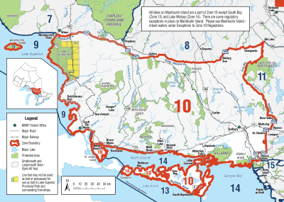
Zone 8
Season Start Date
Season End Date
Sport Limit
5
Conservation Limit
2
Total daily catch and possession limit for all trout, salmon and splake species combined
Additional Fishing Opportunities
Season Start Date
Season End Date
Sport Limit
5
Conservation Limit
2
Additional Fishing Opportunities
- Alvin Lake (49°07′22″N., 81°38′38″W.) - Bradburn Township
- Andrew Lake (48°26′25″N., 80°28′57″W.) - McCann Township
- Armitage Lake (48°23′08″N., 79°54′19″W.) - Thackeray Township
- Arnold Lake 6 (48°13′31″N., 79°52′00″W.) - Arnold Township
- Arrow Lake (48°23′23″N., 80°46′45″W.) - Sheraton Township
- Babs Lake (47°40′38″N., 80°42′51″W.) - Haultain Township
- Bea Lake (48°20′44″N., 79°51′57″W.) - Clifford Township
- Bear Lake (Duff Lake) (49°12′23″N., 81°17′15″W.) - Colquhoun Township
- Bow Lake (48°23′14″N., 80°46′58″W.) - Sheraton Township
- Briere Lake 30 (McEvay Lake 30) (48°19′04″N., 80°35′42″W.) - McEvay Township
- Brinnie Lake (48°25′14″N., 79°58′13″W.) - Thackeray Township
- Burt Lake 4 (48°03′37″N., 80°21′26″W.) - Burt Township
- Burt Lake 5 (48°04′15″N., 80°21′06″W.) - Burt Township
- Camp 22 Lake (47°36′33″N., 83°06′20″W.) - De Gaulle Township
- Canyon Lake (47°54′54″N., 80°43′07″W.) - Yarrow Township
- Carlyle Lake (48°32′47″N., 79°49′50″W.) - Lamplugh Township
- Charles Lake (47°52′03″N., 80°41′11″W.) - Yarrow Township
- Chown Lake 15 (47°42′33″N., 80°35′23″W.) - Chown Township
- Collacutt Lake (47°42′03″N., 79°59′56″W.) - Beauchamp Township
- Collins Lake (48°30′46″N., 79°58′46″W.) - Garrison Township
- Cootie Lake (48°16′37″N., 80°34′28″W.) - McEvay Township
- Deep Lake (48°31′21″N., 80°50′16″W.) - Macklem Township
- Devil’s Punch Bowl Lake (48°45′44″N., 80°47′54″W.) - Calvert Township
- Dewhirst Lake (48°27′43″N., 80°00′33″W.) - Garrison Township
- Docks Lake (47°52′29″N., 81°54′49″W.) - Wigle Township
- Dorothy Lake (48°14′03″N., 80°00′28″W.) - Morrisette Township
- Downey Lake (47°52′39″N., 83°21′15″W.) - Cochrane Township
- Driscoll Lake (48°23′06″N., 79°53′55″W.) - Thackeray Township
- Else Lake (49°01′02″N., 81°09′50″W.) - Fournier Township
- Elspeth Lake (48°17′30″N., 80°42′20″W.) - Timmins Township
- New Emerald Lake (48°52′22″N, 81°07′55″W)
- Eno Lake (49°06′36″N., 80°27′41″W.) - Freele Township
- Fade Lake (48°33′46″N., 80°08′53″W.) - Munro Township
- Ferguson Lake (48°15′23″N., 80°02′36″W.) - Bernhardt Township
- Fisher Lake (48°35′35″N., 80°53′03″W.) - German Township
- Flyline Lake (47°36′11″N., 83°04′20″W.) - De Gaulle Township
- Gale Lake (48°09′54″N., 80°14′45″W.) - Grenfell Township
- Garrison Lake (48°28′59″N., 80°00′15″W.) - Garrison Township
- Gary Lake (47°35′26″N., 81°25′44″W.) - Connaught Township
- George Lake (47°31′15″N., 81°51′38″W.) - Chester Township
- Gerry Lake (47°58′18″N., 80°43′00″W.) - Powell Township
- Giunta Lake (48°22′41″N., 79°53′48″W.) - Thackeray Township
- Green Lake (48°34′25″N., 80°52′22″W.) - German Township, Kettle Lakes Provincial Park
- Greenock Lake (48°18′33″N., 80°44′03″W.) - Timmins Township
- Grey Lake (48°17′31″N., 80°34′46″W.) - McEvay Township
- Harvey Lake (47°36′19″N., 83°04′55″W.) - De Gaulle Township
- Heart Lake (48°34′39″N., 80°53′03″W.) - German Township, Kettle Lakes Provincial Park
- Hewitt Lake (48°30′47″N., 80°01′43″W.) - Michaud Township
- Holster Lake (48°16′07″N., 80°44′25″W.) - Michie Township
- Hope Lake (48°22′46″N., 81°26′18″W.) - Ogden Township
- Hornet Lake 42 (47°51′49″N., 81°54′20″W.) - Wigle Township
- Hutch Lake (48°19′15″N., 80°43′16″W.) - Timmins Township
- Imperial Lake (48°29′28″N., 79°48′30″W.) - Harker Township
- Island Lake (48°47′44″N., 80°33′26″W.) - Teefy Township
- James Lake (47°52′40″N., 80°41′08″W.) - Yarrow Township
- Jessup Lake (48°16′04″N., 80°34′18″W.) - Nordica Township
- John Lake (47°52′50″N., 80°43′35″W.) - Yarrow Township
- June Lake (48°29′13″N., 80°50′09″W.) - Macklem Township
- Kidney Lake (49°14′34″N., 81°18′38″W.) - Colquhoun Township
- Knothole Lake (47°42′43″N., 81°27′40″W.) - Togo Township
- La Violette Lake (48°33′46″N., 80°51′41″W.) - German Township, Kettle Lakes Provincial Park
- Lake 1 (48°07′41″N., 82°31′35″W.) - Ivanhoe Township
- Lake 2 (A Lake) (47°40′28″N., 81°51′32″W.) - Somme Township
- Lake 3 (Tahill Lake) (47°40′47″N., 81°51′41″W.) - Somme Township
- Lake 4 (48°03′32″N., 82°31′33″W.) - Silk Township
- Lake 5 (49°29′43″N., 82°19′11″W.) - Teetzel Township
- Lake 9 (48°08′38″N., 82°31′18″W.) - Ivanhoe Township
- Lake 9 (47°51′21″N., 81°48′22″W.) - Middleboro Township
- Lake 9 (49°30′50″N., 82°19′49″W.) - Teetzel Township
- Lake 10 (49°31′25″N., 82°19′45″W.) - Teetzel Township
- Lake 11 (49°35′06″N., 82°19′11″W.) - Pearce Township
- Lake 15 (47°38′30″N., 83°08′25″W.) - Nimitz Township
- Lake 36B (47°41′11″N., 81°52′07″W.) - Somme Township
- Lake 42 (48°05′56″N., 82°31′47″W.) - Ivanhoe Township
- Lake 50 (48°04′12″N., 82°31′24″W.) - Ivanhoe Township
- Lake 52 (48°03′43″N., 82°31′33″W.) - Ivanhoe Township
- Lake 53 (48°03′42″N., 82°31′23″W.) - Ivanhoe Township
- Lake 56 (48°01′27″N., 81°17′13″W.) - English Township
- Lake 64 (49°49′14″N., 82°19′49″W.) - Guilfoyle Township
- Lake 68 (49°49′49″N., 82°19′60″W.) - Guilfoyle Township
- Lake 222412 (48°13′17″N., 82°02′53″W.) - Reeves Township
- Leatherleaf Lake (47°40′30″N., 83°11′31″W.) - Halsey Township
- Little Club Lake (48°27′37″N., 80°48′49″W.) - Macklem Township
- Little Elephant Head 23 Lake (47°34′43″N., 81°23′12″W.) - Miramichi Township
- Little Gibson Lake (48°27′07″N., 80°49′01″W.) - Macklem Township
- Mall Lake (48°20′30″N., 79°53′00″W.) - Clifford Township
- Matti Lake (47°48′17″N., 83°08′41″W.) - McNaught Township
- Maurice Lake (47°52′12″N., 80°41′26″W.) - Yarrow Township
- McCulloch Lake (48°30′59″N., 80°05′02″W.) - Michaud Township
- McEvay Lake 18 (48°17′30″N., 80°39′13″W.) - McEvay Township
- Mearow Lake (47°45′42″N., 80°06′13″W.) - Robillard Township
- Midway Lake (48°10′01″N., 82°29′04″W.) - Ivanhoe Township
- Milligan Lake (48°37′49″N., 80°07′36″W.) - Milligan Township
- Moon Lake (47°40′18″N., 81°03′39″W.) - Knight Township
- Mountain Lake (47°49′37″N., 80°09′60″W.) - Truax Township
- Neannin Lake (47°47′04″N., 81°22′30″W.) - Burrows Township
- Neezin Lake (47°49′08″N., 81°21′09″W.) - Burrows Township
- Nelson Lake (48°14′16″N., 79°52′31″W.) - Arnold Township
- Packsack Lake (48°50′21″N., 80°17′13″W.) - Moody Township
- Pall Lake (48°20′56″N., 79°53′03″W.) - Clifford Township
- Partridge Lake (48°41′50″N., 81°00′58″W.) - Evelyn Township
- Pearl Lake (47°52′02″N., 81°53′01″W.) - Wigle Township
- Pothole 6 (48°28′33″N., 79°59′58″W.) - Garrison Township
- Potvin Lake (48°17′51″N., 80°35′09″W.) - McEvay Township
- Price Lake (49°07′23″N., 81°38′29″W.) - Bradburn Township
- Ramey Lake (48°18′02″N., 79°53′13″W.) - Clifford Township
- Ray Lake (47°29′05″N., 81°51′45″W.) - Invergarry Township
- Regis Lake (47°45′36″N., 83°14′30″W.) - McNaught Township
- Roger Lake (Chester Lake 34) (47°31′02″N., 81°51′38″W.) - Chester Township
- Round Lake (48°28′58″N., 80°50′10″W.) - Macklem Township
- Rozon Lake (48°15′47″N., 79°52′48″W.) - Arnold Township
- Scotties Lake 48 (47°40′14″N., 81°12′47″W.) - Kelvin Township
- Seahorse Lake (48°18′45″N., 79°52′49″W.) - Clifford Township
- Sigs Lake (47°41′37″N., 80°41′20″W.) - Haultain Township
- Sootheran Lake (47°46′34″N., 83°20′59″W.) - Gallagher Township
- South Triple Lake (48°26′18″N., 80°48′14″W.) - Sheraton Township
- Strong Lake (47°59′24″N., 80°42′18″W.) - Powell Township
- Sullivan Lake (48°16′40″N., 79°42′22″W.) - Ben Nevis Township
- Susanne Lake (47°36′04″N., 81°51′46″W.) - Neville Township
- Tailleurs Lake (49°03′32″N., 81°12′29″W.) - Clute Township
- Taylor Lake 43 (47°51′59″N., 81°54′21″W.) - Wigle Township
- Thackeray Lake 9 (48°23′45″N., 79°53′57″W.) - Thackeray Township
- Thrasher Lake (48°21′32″N., 79°52′28″W.) - Clifford Township
- Tracy Lake (49°16′02″N., 81°17′48″W.) - Colquhoun Township
- Trotter Lake (47°57′51″N., 81°56′02″W.) - Regan Township
- Vannier Lake (48°18′13″N., 79°52′58″W.) - Clifford Township
- New Verte Lake (48°53′00.7″N, 81°07′28″W)
- Wanatangua Lake (47°37′42″N., 81°27′23″W.) - Connaught Township
- Wee Lake (47°57′12″N., 81°55′07″W.) - Regan Township
- Whopper Lake (47°49′30″N., 81°52′40″W.) - Whalen Township
- Wine Lake (47°49′08″N., 81°52′23″W.) - Whalen Township
- Wiskin Lake (49°11′57″N., 81°17′28″W.) - Colquhoun Township
- Wolverton Lake (48°16′32″N., 80°43′59″W.) - Michie Township
- Wright’s Lake (47°49′60″N., 81°53′35″W.) - Whalen Township
- Wuskwi Lake (47°50′34″N., 83°13′58″W.) - McNaught Township
- Yarrow Lake 10 (47°53′40″N., 80°41′33″W.) - Yarrow Township
- Yarrow Lake 19 (47°54′09″N., 80°43′51″W.) - Yarrow Township
Total daily catch and possession limit for all trout, salmon and splake species combined
Zone 9
Season Start Date
Season End Date
Sport Limit
1
Conservation Limit
0
must be greater than 56 cm ( 22" )
Total daily catch and possession limit for all trout, salmon and splake species combined
Zone 10
Season Start Date
Season End Date
Sport Limit
5
Conservation Limit
2
Total daily catch and possession limit for all trout, salmon and splake species combined
Additional Fishing Opportunities
Season Start Date
Season End Date
Sport Limit
5
Conservation Limit
2
Additional Fishing Opportunities
- See Species Exceptions section below for full details
Total daily catch and possession limit for all trout, salmon and splake species combined
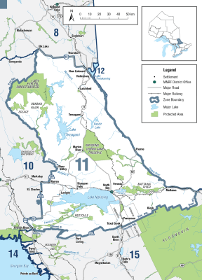
Zone 11
Season Start Date
Season End Date
Sport Limit
5
Conservation Limit
2
Sport limit: not more than 1 greater than 31 cm ( 12 1/4" )
Conservation limit: none greater than 31 cm ( 12 1/4" )
Total daily catch and possession limit for all trout, salmon and splake species combined
Additional Fishing Opportunities
Season Start Date
Season End Date
Sport Limit
5
Conservation Limit
2
Additional fishing opportunities
- Barnett Lake (47°09′05″N., 80°02′37″W.) - Aston Township
- Bartle Lake (47°30′00″N., 79°50′00″W.) - Hudson Township
- Bastien Lake (Tower Lake) (46°23′56″N., 78°54′52″W.) - Mattawan Township
- Beach Lake (46°44′11″N., 79°47′48″W.) - Sisk Township
- Best Lake 73 (47°09′30″N., 79°45′41″W.) - Best Township
- Brown’s Lake (47°06′57″N., 80°05′18″W.) - Cynthia Township
- Coppersand Lake (47°08′44″N., 80°03′47″W.) - Aston Township
- Dokis Pond (46°07′23″N., 80°02′46″W.) - Dokis Number 9 First Nation
- Fork Lake (46°09′13″N., 78°43′53″W.) - Boyd Township
- Froggy Lake (46°17′12″N., 79°07′22″W.) - Bonfield Township
- Gillies Limit Lake 19 (47°16′04″N., 79°46′59″W.) - Gillies Limit Township
- Gillies Limit Lake 51 (47°16′57″N., 79°42′44″W.) - Gillies Limit Township
- Glassy Lake (46°23′16″N., 79°06′50″W.) - Phelps Township
- Herbert Lake (46°58′48″N., 80°08′17″W.) - Joan Township
- High Lake (46°53′46″N., 80°20′28″W.) - Afton Township
- Hillcrest Lake (47°00′52″N., 80°03′24″W.) - Joan Township
- Hook Lake (47°08′10″N., 79°50′47″W.) - Strathy Township
- Hush Hush Lake (47°08′12″N., 80°02′54″W.) - Cynthia Township
- Indian Lake (46°28′05″N., 79°08′19″W.) - French Township
- Lake 697 (46°29′51″N., 79°04′00″W.) - Butler Township
- Lake 2 (Pothole 2) (46°30′12″N., 79°09′44″W.) - French Township
- Little McConnell Lake (46°45′12″N., 79°20′13″W.) - McAuslan Township
- Love Lake (45°59′20″N., 79°19′47″W.) - Himsworth Township
- Malloch Lake (47°04′43″N., 80°03′04″W.) - Cynthia Township
- Mirror Lake (46°25′24″N., 79°07′05″W.) - Phelps Township
- Montreuil Lake (46°25′54″N., 78°54′28″W.) - Mattawan Township
- Mowat Lake (47°28′51″N., 79°57′37″W.) - Barr Township
- Mug Lake (46°44′33″N., 79°22′30″W.) - McAuslan Township
- Norway Lake (46°45′08″N., 79°15′08″W.) - Wyse Township
- Pine Lake (46°44′47″N., 79°16′39″W.) - McAuslan Township
- Pole Lake (46°43′44″N., 79°21′51″W.) - McAuslan Township
- Price Lake (46°58′03″N., 80°07′32″W.) - Phyllis Township
- Quarry Lake (46°43′43″N., 79°21′12″W.) - McAuslan Township
- Redbark Lake (46°59′45″N., 80°09′55″W.) - Joan Township
- Robert Lake (Head Lake) - (47°16′01″N., 79°51′36″W.) - Brigstocke Township
- Roko Lake (47°07′12″N., 80°02′52″W.) - Cynthia Township
- Round Lake (46°46′34″N., 79°18′55″W.) - McAuslan Township
- Secord Lake (46°45′25″N., 79°24′54″W.) - La Salle Township
- Side Rock Lake (47°04′36″N., 80°03′34″W.) - Cynthia Township
- Strathcona Lake 25 (47°01′23″N., 79°46′40″W.) - Strathcona Township
- Teasdale Lake (46°21′20″N., 79°02′30″W.) - Olrig Township
- Turtle Lake (46°09′15″N., 79°01′52″W.) - Boulter Township
- Whitefawn Lake (46°23′23″N., 79°27′53″W.) - Widdifield Township
Total daily catch and possession limit for all trout, salmon and splake species combined
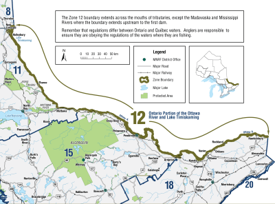
Zone 12
Season Start Date
Season End Date
Sport Limit
5
Conservation Limit
2
Total daily catch and possession limit for all trout, salmon and splake species combined
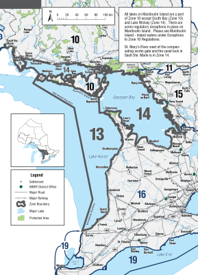
Zone 13

Season Start Date
Season End Date
Closed to fishing
Closed to fishing
Not present in this Zone and are closed to fishing all year
Zone 14
Season Start Date
Season End Date
Closed to fishing
Closed to fishing
Not present in this Zone and are closed to fishing all year
Zone 15
Additional Fishing Opportunities
Season Start Date
Season End Date
Sport Limit
5
Conservation Limit
2
Additional Fishing Opportunities
- Aide Lake (45°00′35″N., 77°33′12″W.) - Cashel Township
- Barns Lake (45°36′19″N., 78°08′15″W.) - Murchison Township
- Black Cat Lake (45°11′01″N., 78°41′52″W.) - Sherborne Township
- Bronson Lake (45°02′31″N., 77°46′02″W.) - Dungannon Township
- Burdock Lake (45°10′21″N., 78°35′11″W.) - Guilford Township
- Burnt Lake (45°01′37″N., 77°53′07″W.) - Faraday Township
- Burnt River (44°53′N., 78°38′W.) - Snowdon Township
- Cat Lake (45°10′37″N., 78°40′47″W.) - Stanhope Township
- Cedar Lake (44°58′38″N., 77°45′53″W.) - Dungannon Township
- Centre Lake (45°00′51″N., 78°03′00″W.) - Cardiff Township
- Cherrytree Lake (45°04′12″N., 77°36′21″W.) - Mayo Township
- Davis Pond (45°18′55″N., 77°48′23″W.) - Wicklow Township
- Doe Lake (44°56′26″N., 78°53′54″W.) - Anson Township
- Dovetail Lake (45°01′13″N., 77°37′24″W.) - Mayo Township
- East Chainy Lake (45°12′25″N., 78°04′16″W.) - McClure Township
- Finger Lake (45°35′13″N., 77°48′27″W.) - Dickens Township
- Fish Lake (45°32′29″N., 77°50′48″W.) - Dickens Township
- Gil Lake (44°53′07″N., 78°10′21″W.) - Anstruther Township
- Glennie’s Pond (45°12′48″N., 78°46′14″W.) - Sherborne Township
- Green Canoe Lake (45°10′44″N., 78°28′00″W.) - Harburn Township
- Green Lake (45°28′30″N., 77°59′25″W.) - Lyell Township
- Harburn Lake (45°12′46″N., 78°26′41″W.) - Harburn Township
- Hardings Lake (45°00′19″N., 78°04′57″W.) - Cardiff Township
- Hicks Lake (45°22′27″N., 77°49′27″W.) - Bangor Township
- Ike’s Pond (45°11′37″N., 78°27′51″W.) - Harburn Township
- Inright Lake (45°23′25″N., 77°51′21″W.) - Wicklow Township
- James Lake (45°21′25″N., 77°43′36″W.) - Bangor Township
- Ketch Lake (45°01′48″N., 78°57′20″W.) - Hindon Township
- Lake on the Hill (45°25′54″N., 77°59′05″W.) - Lyell Township
- Leatherroot Lake (45°11′32″N., 78°03′16″W.) - Herschel Township
- Lennon Lake (45°17′50″N., 77°40′44″W.) - Carlow Township
- Little Birch Lake (45°00′07″N., 77°33′04″W.) - Cashel Township
- Little Bob Lake (44°55′19″N., 78°22′57″W.) - Glamorgan Township
- Little Clear Lake (44°46′52″N., 78°23′47″W.) - Cavendish Township
- Little Copper Lake (44°47′28″N., 78°11′32″W.) - Anstruther Township
- Little Echo Lake (44°54′50″N., 78°10′04″W.) - Monmouth Township
- Little Otter Lake (44°54′08″N., 78°52′11″W.) - Anson Township
- Long Lake (45°03′21″N., 78°08′19″W.) - Cardiff Township
- Lunch Lake (45°33′17″N., 78°14′23″W.) - Airy Township
- Mawson Lake (44°56′26″N., 77°35′08″W.) - Cashel Township
- McCormick Lake (45°20′28″N., 77°46′46″W.) - Bangor Township
- McFee Lake (45°31′20″N., 78°06′44″W.) - Airy Township
- Mitchell Lake (45°04′10″N., 78°00′34″W.) - Herschel Township
- Moonbeam Lake (45°34′16″N., 78°08′17″W.) - Airy Township
- Nehemiah Lake (45°12′15″N., 78°48′18″W.) - Sherborne Township
- North Chainy Lake (45°12′29″N., 78°04′33″W.) - McClure Township
- Otherside Lake (45°34′26″N., 78°04′31″W.) - Murchison Township
- Paradise Lake (45°37′23″N., 77°54′28″W.) - Dickens Township
- Partridge Lake (45°07′50″N., 78°47′18″W.) - Stanhope Township
- Pat Lake (45°18′19″N., 78°04′49″W.) - McClure Township
- Pell Lake (45°25′30″N., 77°57′06″W.) - Lyell Township
- Poplar Pond (45°21′29″N., 77°48′17″W.) - Bangor Township
- Potash Lake (45°22′45″N., 77°49′41″W.) - Bangor Township
- Rabbit Lake (45°11′15″N., 78°44′14″W.) - Sherborne Township
- Rock Lake (45°03′48″N., 77°40′33″W.) - Dungannon Township
- Ronald Lake (45°12′33″N., 78°48′09″W.) - Sherborne Township
- Salt Lake (45°10′57″N., 77°33′56″W.) - Carlow Township
- Seesaw Lake (45°33′41″N., 78°11′35″W.) - Airy Township
- Silver Buck Lake (45°09′45″N., 78°47′33″W.) - Sherborne Township
- Silver Doe Lake (45°09′59″N., 78°47′42″W.) - Sherborne Township
- Silversheen Lake (45°17′48″N., 78°05′05″W.) - McClure Township
- Sleeper Lake (Green Lake) (45°00′57″N., 77°28′32″W.) - Cashel Township
- Sunbeam Lake (45°39′41″N., 78°41′21″W.) - McLaughlin Township
- Swordfingal Lake (45°02′27″N., 77°37′04″W.) - Mayo Township
- Tim Lake (45°07′41″N., 77°53′02″W.) - Herschel Township
- Trout Lake (Alsever Lake) (45°31′00″N., 77°58′36″W.) - Murchison Township
- Tub Lake (45°30′52″N., 77°58′03″W.) - Murchison Township
- Tuya Lake (45°33′04″N., 78°08′37″W.) - Airy Township
- Twin Lake (45°00′34″N., 78°04′33″W.) - Cardiff Township
- West Headstone Lake (45°34′15″N., 78°13′47″W.) - Airy Township
- Wish Lake (45°36′44″N., 78°05′07″W.) - Murchison Township
Season: open all year
Bait restriction: live fish may not be used as bait or possessed for use as bait, regardless of what species is/are being targeted
- Adams Lake (44°59′07″N., 78°10′25″W.) - Cardiff Township
- Burleigh Lake (44°52′22″N., 78°05′00″W.) - Chandos Township
- Currie Lake (44°58′24″N., 77°36′37″W.) - Cashel Township
- Dixie Lake (45°02′16″N., 78°08′53″W.) - Cardiff Township
- Halls Lake (45°01′35″N., 78°10′36″W.) - Cardiff Township
- Jimmie Lake (44°59′26″N., 77°39′12″W.) - Dungannon Township
- Johnson Lake (45°22′46″N., 77°52′52″W.) - Wicklow Township
- Lost Lake (45°10′14″N., 78°52′09″W.) - Ridout Township
- Lowry Lake (44°55′53″N., 78°15′02″W.) - Monmouth Township
- No Name Lake (45°10′51″N., 78°44′58″W.) - Sherborne Township
- North Moonbeam Lake (Sawlog Lake) (45°35′05″N., 78°07′11″W.) - Murchison Township
- Pritchard Lake (45°06′23″N., 77°34′45″W) - Mayo Township
- Runaround Lake (44°52′27″N., 78°12′27″W.) - Anstruther Township
- Shoelace Lake (45°12′38″N., 78°45′19″W.) - Sherborne Township
- Stethan Lake (44°50′37″N., 78°07′46″W.) - Anstruther Township
- Stick Lake (44°50′30″N., 78°11′16″W.) - Anstruther Township
- Tommy’s Lake (44°58′50″N., 77°36′44″W.) - Cashel Township
- Wicklow Lake (45°21′25″N., 77°58′05″W.) - Wicklow Township
- Yuill Lake - Wicklow Township
Limits: S-2 and C-2; must be greater than 36 cm ( 14 1/8" )
Gear restriction: only artificial lures may be used, regardless of what species is/are being targeted
- Animoosh Lake - Dickson and Niven Townships
- Harry Lake - Lawrence Township
- Rence Lake - Lawrence Township
- Welcome Lake - Lawrence and Nightingale Townships
Limits: S-2 and C-2; must be greater than 46 cm ( 18" )
Gear restriction: only artificial lures may be used, regardless of what species is/are being targeted
- Westward Lake - Peck Township
Limits: S-2 and C-2
Gear restriction: only artificial lures may be used, regardless of what species is/are being targeted
- Little Crooked Lake - Dickson Township
- Scott Lake - Peck Township
Season: fourth Saturday in April to September 30
Limits: S-5 and C-2; must be greater than 28 cm ( 11" )
Bait restriction: live fish may not be used as bait or possessed for use as bait, regardless of what species is/are being targeted
- Baldcoot Lake - Bangor Township
- Blairs Lake - Wicklow Township
- East Lake (45º07′N., 78º15′ W.) - Harcourt Township
- Echo Lake - Bangor Township
- Evans Lake - Wicklow Township
- Greenbark Lake - McClure Township
- Hawk Lake - Wicklow Township
- Hound Lake - Herschel Township
- Little Meach Lake - McClure Township
- Meach Lake - McClure Township
- Mitchell Lake - McClure Township
- Rocky Lake - Mayo Township
- Sud Lake - McClure Township
Season: fourth Saturday in April to September 30
Bait restriction: live fish may not be used as bait or possessed for use as bait, regardless of what species is/are being targeted
- Nelson Lake (45°29′33″N., 78°57′32″W.) - Finlayson Township
Total daily catch and possession limit for all trout, salmon and splake species combined
Season Start Date
Season End Date
Sport Limit
5
Conservation Limit
2
Total daily catch and possession limit for all trout, salmon and splake species combined
Zone 16
Season Start Date
Season End Date
Sport Limit
5
Conservation Limit
2
Total daily catch and possession limit for all trout, salmon and splake species combined
Additional Fishing Opportunities
Season Start Date
Season End Date
Sport Limit
5
Conservation Limit
2
Additional fishing opportunities
- Bells Lake (44°19′15″N., 80°44′09″W.) - Glenelg Township
Total daily catch and possession limit for all trout, salmon and splake species combined
Zone 17
Season Start Date
Season End Date
Sport Limit
2
Conservation Limit
1
Total daily catch and possession limit for all trout, salmon and splake species combined
Zone 18
Season Start Date
Season End Date
Sport Limit
5
Conservation Limit
2
Total daily catch and possession limit for all trout, salmon and splake species combined
Zone 19
Season Start Date
Season End Date
Closed to fishing
Closed to fishing
Not present in this Zone and are closed to fishing all year
Zone 20
Season Start Date
Season End Date
Closed to fishing
Closed to fishing
Not present in this Zone and are closed to fishing all year
Region 1
Additional Fishing Opportunities
Season Start Date
Season End Date
Limit
5
Haida Gwaii Daily Quotas
Not more than
- 1 over 50 cm
- 2 from streams
And you must release:
- Trout/char under 30 cm from streams
Total daily catch of 5 for all trout/char species combined
Season Start Date
Season End Date
Limit
0
Catch and release only
Total daily catch of 4 for all trout/char species combined
Region 2
Season Start Date
Season End Date
Limit
4
Not more than
- 1 over 50 cm
- 2 from streams (must be hatchery)
And you must release:
- Wild trout/char from streams
- Hatchery trout/char under 30 cm from streams
NOTE: There is no general minimum size limit for trout in lakes.
Total daily catch of 4 for all trout/char species combined
Region 3
Season Start Date
Season End Date
Limit
5
Not more than
- 4 from streams
- 1 over 50 cm
Total daily catch of 5 for all trout/char species combined
Region 4
Season Start Date
Season End Date
Limit
5
but not more than
- 2 from streams
Total daily catch of 5 for all trout/char species combined
Region 5
Season Start Date
Season End Date
Limit
5
but not more than
- 1 over 50 cm
- 2 from streams
Total daily catch of 5 for all trout/char species combined
Region 6
Season Start Date
Season End Date
Limit
5
Not more than
- 1 over 50 cm
- 1 from streams Jul 1 - Oct 31
And you must release
- Trout under 30 cm from any stream
- Trout of any size from streams Nov 1 - June 30
Total daily catch of 5 for all trout/char species combined
Region 7A
Season Start Date
Season End Date
Limit
5
Not more than
- 1 over 50 cm
- 2 from streams
Total daily catch of 5 for all trout/char species combined
Region 7B
Season Start Date
Season End Date
Limit
5
but not more than
- 1 over 50 cm
- 2 from streams
Total daily catch of 5 for all trout/char species combined
Region 8
Season Start Date
Season End Date
Limit
5
but not more than
- 1 over 50 cm
- 4 from streams (only 2 over 30 cm)
Total daily catch of 5 for all trout/char species combined
Additional Fishing Opportunities
Season Start Date
Season End Date
Limit
20
but not more than
- 1 over 50 cm
And you may retain:
- 20 from streams
Copyright © 2026 What To Fish. All Rights Reserved.
Site by Sage
Solutions