By Location
By Species
What's In Season by Species
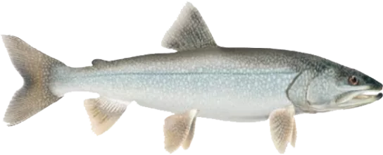
Showing all regulations for Lake Trout.
- Not in Season
- Open in Limited Locations
- Open Season
Show All
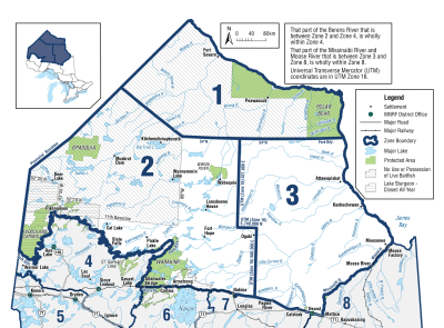
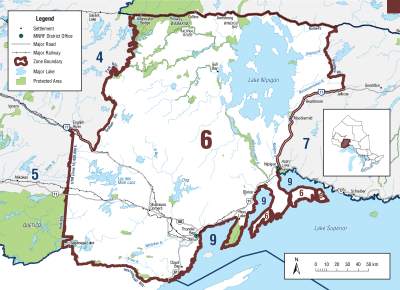
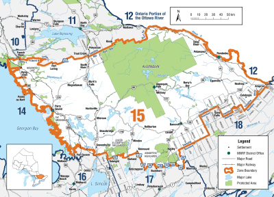
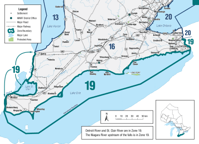
Zone 1

Season Start Date
Season End Date
Sport Limit
3
Conservation Limit
1
Total daily catch and possession limit for all trout and salmon species combined
Zone 2
Season Start Date
Season End Date
Sport Limit
2
Conservation Limit
1
Limits: S-2; not more than 1 greater than 56 cm ( 22" ) from September 1 to September 30, no size limit rest of year and C-1; any size
Limits: S-1 and C-0
- Faircloth Lake (Greytrout Lake) (51°09’20”N., 88°11’24”W.)
- Merpaw Lake (51°38’53”N., 88°58’13”W.)
Limits: S-1 in one day and possession limit of 2, not more than 1 greater than 65 cm and C-1; any size
- Echoing Lake
Limits: S-2 and C-1; not more than 1 greater than 56 cm
- Gordon Reid Lake (South Lake, I-100 Lake) (51°01’14”N., 88°02’37”W.)
- Luella Lake (51°11’20”N., 88°42’26”W.)
- Opichuan Lake (51°14’46”N., 87°46’14”W.)
- O’Sullivan Lake (50°25’00”N., 87°03’00”W.)
- Superb Lake (50°30’55”N., 86°58’21”W.)
- Troutfly Lake (51°41’59”N., 88°53’22”W.)
Total daily catch and possession limit for all trout and salmon species combined
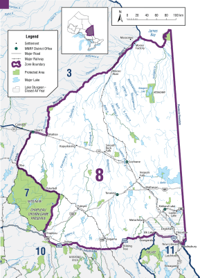
Zone 3

Additional Fishing Opportunities
Season Start Date
Season End Date
Sport Limit
3
Conservation Limit
1
- Brave Lake (49°51’15”N., 84°20’43”W.) - Auden Township
Season Start Date
Season End Date
Sport Limit
3
Conservation Limit
1
Total daily catch and possession limit for all trout, salmon and splake species combined
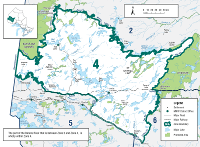
Zone 4
Season Start Date
Season End Date
Closed to fishing
Closed to fishing
Season: closed all year
-
Cedarbough Lake (49°58’49”N., 92°11’37”W.) and all connecting streams to Little Vermilion Lake (50°00’06”N., 92°09’18”W.)
-
Little Vermilion Lake (50°00’06”N., 92°09’18”W.) and all connecting streams to Cedarbough Lake (49°58’49”N., 92°11’37”W.)
Season Start Date
Season End Date
Sport Limit
2
Conservation Limit
1
Not more than 1 greater than 56 cm ( 22" )
Total daily catch and possession limit for all trout, salmon and splake species combined
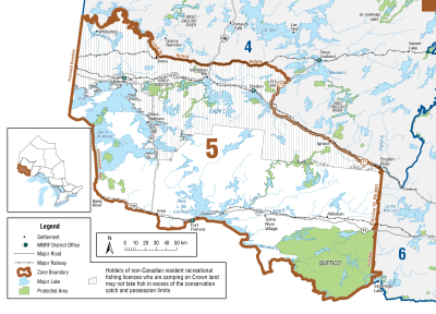
Zone 5
Season Start Date
Season End Date
Sport Limit
2
Conservation Limit
1
Ontario and Canadian residents only
Not more than 1 greater than 56 cm ( 22" ) from September 1 to September 30
Total daily catch and possession limit for all trout, salmon and splake species combined
Season Start Date
Season End Date
Sport Limit
1
Conservation Limit
1
Non-Canadian residents only
Possession limit: S-2, not more than 1 greater than 56 cm ( 22" ) from September 1 to September 30, and C-1, no size limit
Total daily catch and possession limit for all trout, salmon and splake species combined
Season Start Date
Season End Date
Closed to fishing
Closed to fishing
Season: closed all year
- Centre for Northern Forest Ecosystem Research Lakes:
- Lake 20 (49°07’46”N., 92°08’19”W.)
- Lake 26 (49°07’23”N., 92°08’40”W.)
- Lake 39 (49°05’42”N., 92°09’56”W.)
- Lake 42 (49°05’05”N., 92°09’36”W.)
- Contact Atikokan District Office for more information
- Seahorse Lake (49°06’03”N., 93°18’03”W.)
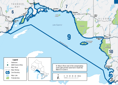
Zone 6
Season Start Date
Season End Date
Sport Limit
2
Conservation Limit
1
not more than 1 greater than 56 cm ( 22" ) from September 1 to September 30. No size limit the rest of the season
Total daily catch and possession limit for all trout, salmon and splake species combined
Additional Fishing Opportunities
Season Start Date
Season End Date
Sport Limit
2
Conservation Limit
1
no size limit
- Black Sturgeon Lake (49°19’27”N., 88°51’34”W.)
- Keemle Lake (49°17’00”N., 88°07’00”W.)
- Pasha Lake (49°42’00”N., 87°43’00”W.) - Walters Township
- Pass Lake (48°33′45″N, 88°44′05″W)
Total daily catch and possession limit for all trout, salmon and splake species combined
Season Start Date
Season End Date
Closed to fishing
Closed to fishing
Season: closed all year
-
Shebandowan Lakes (48°38’53”N., 90°19’22”W.)
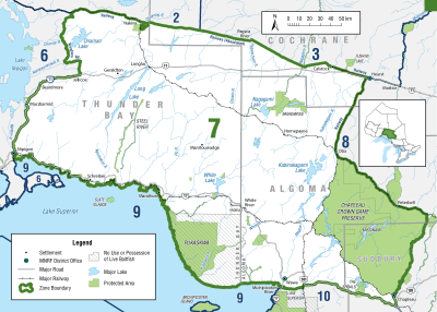
Zone 7
Season Start Date
Season End Date
Sport Limit
2
Conservation Limit
1
Total daily catch and possession limit for all trout, salmon and splake species combined
Additional Fishing Opportunities
Season Start Date
Season End Date
Sport Limit
2
Conservation Limit
1
Additional Fishing Opportunities
- Arnott Lake (49°35’53”N., 84°36’24”W.) - Arnott Township
- Bear Trap Lake (48°15’35”N., 87°31’04”W.)
- Beaton Lake 65 (Loon Lake) (48°58’51”N., 84°47’51”W.) - Beaton Township
- Big Skunk Lake (49°35’25”N., 84°33’33”W.) - Arnott Township
- Corine Lake (49°33’21”N., 84°35’44”W.) - McEwing Township
- McLeod Lake (49°31’52”N., 86°33’13”W.)
- Raynar Lake (49°58’29”N., 86°29’40”W.) – Raynar Township
- Redpine Lake (49°38’02”N., 84°32’30”W.) - Arnott Township
- Young Lake (49°35’27”N., 84°40’02”W.) - Arnott Township
Limits: S-2 and C-1; not more than 1 greater than 56 cm ( 22" )
- Fernow Lake (49°54’52”N., 86°03’18”W.) - Fernow Township
- McKay Lake (49°37’14”N., 86°25’19”W.)
Limits: S-1 and C-0
- Grehan Lake (49°29’N., 86°37’W.)
- Little Pic Lake (49°22’N., 86°38’W.)
- Sun Lake (49°25’N., 86°34’W.)•Yucca Lake (49°23’N., 86°37’W.)
Total daily catch and possession limit for all trout, salmon and splake species combined
Zone 8
Season Start Date
Season End Date
Sport Limit
3
Conservation Limit
1
Total daily catch and possession limit for all trout, salmon and splake species combined
Season Start Date
Season End Date
Sport Limit
3
Conservation Limit
1
Total daily catch and possession limit for all trout, salmon and splake species combined
Additional Fishing Opportunities
Season Start Date
Season End Date
Sport Limit
3
Conservation Limit
1
Additional Fishing Opportunities
- Blue Lake (49°11′14″N., 81°16′17″W.) - Clute Township
- Clearwater Lake (48°41′17″N., 80°59′42″W.) - Evelyn Township
- Crawfish Lake (48°51′20″N., 81°07′11″W.) - Duff Township
- Doucette Lake (48°54′51″N., 80°38′27″W.) - Mortimer Township
- Duck Lake (49°20’22”N., 82°21’34”W.) - O’Brien Township
- Elmer Lake (47°52′43″N., 80°50′01″W.) - Doon Township
- Eva Lake (Clear Lake) (49°15′10″N., 82°13′42″W.) - Nansen Township
- Flipper Lake (48°49′42″N., 80°16′30″W.) - Moody Township
- Jerry Lake (49°31′13″N., 80°19′27″W.) - Tweed Township
- Ketchini Lake (47°51′01″N., 81°54′26″W.) - Wigle Township
- Kwitosse Lake (47°47′06″N., 81°22′52″W.) - Burrows Township
- Laidlaw Lake (48°56′04″N., 81°47′50″W.) - Kirkland Township
- Laughton Lake (Lake 15F-47) (49°15′04″N., 80°43′46″W.) - Laughton Township
- Long Lake (47°48′58″N., 80°08′15″W.) - Robillard Township
- Lulu Lake (48°19′44″N., 79°52′52″W.) - Clifford Township
- Macfie Lake (47°44′57″N., 81°23′47″W.) - Cabot Township
- Mary Lake (48°53′31″N., 80°49′45″W.) - St John Township
- Mesomikenda Lake (47°38′53″N., 81°52′43″W.) - Neville Township
- Miller Lake (47°39′39″N., 80°43′24″W.) - Nicol Township
- Mistango Lake (49°07′23″N., 80°27′12″W.) - Freele Township
- Nansen Lake (49°14′54″N., 82°13′35″W.) - Nansen Township
- Nellie Lake (48°47′43″N., 80°47′34″W.) - Calvert Township
- Nettie Lake (48°13′19″N., 79°59′21″W.) - Morrisette Township
- Paddy Lake (48°52′58″N., 81°08′15″W.) - Duff Township
- Pallet Lake (48°50′48″N., 81°07′01″W.) - Duff Township
- Pearce 24 Lake (49°39’19”N., 82°18’22”W.) - Pearce Township
- Perry Lake (48°31′41″N., 80°06′22″W.) - Michaud Township
- Pine Lake (49°14′34″N., 79°54′27″W.) - Kenning Township
- Rancourt Lake (49°04′48″N., 81°12′33″W.) - Clute Township
- Return Lake (48°59′22″N., 81°46′43″W.) - Laidlaw Township
- Secret Lake 38 (47°46′56″N., 81°41′47″W.) - Stetham Township
- Semple Lake (48°00′04″N., 81°17′60″W.) - Semple Township
- Sibbald Lake (48°48′31″N., 80°34′31″W.) - Edwards Township
- Smith Lake (49°54′31″N., 81°59′36″W.) - Howells Township
- Star Lake (49°21′24″N., 81°47′20″W.) - Alexandra Township
- Starvation Lake (49°24′44″N., 80°27′19″W.) - Bragg Township
- Sunny Lake (48°09′40″N., 80°31′60″W.) - Dunmore Township
- Traill Lake (48°51′25″N., 80°18′23″W.) - Moody Township
- Wendigo Lake (47°52′12″N., 79°41′57″W.) - Bayly Township
- Zinger Lake (49°25′25″N., 80°44′35″W.) - Potter Township
Total daily catch and possession limit for all trout, salmon and splake species combined
Zone 9
Season Start Date
Season End Date
Sport Limit
3
Conservation Limit
1
Total daily catch and possession limit for all trout, salmon and splake species combined
Zone 10
Additional Fishing Opportunities
Season Start Date
Season End Date
Sport Limit
2
Conservation Limit
1
- Avery Lake (47°08′38″N., 81°13′58″W.) - Frechette Township
- Barnet Lake (47°10′52″N., 81°10′39″W.) - Leask Township
- Burwash Lake (47°07′46″N., 81°02′46″W.) - Cotton Township
- Chrysler Lake (47°28′16″N., 81°06′27″W.) - Ogilvie Township
- Edna Lake (47°04′44″N., 81°13′45″W.) - Frechette Township
- Flagg (47°47′33″N., 84°17′51″W.) and Gould lakes (47°48′33″N., 84°17′07″W.) and all connecting waters and tributaries - Sampson Township, District of Algoma
- Lake 44 (47°10′50″N., 81°05′38″W.) - Leask Township
- Lake 65 - Valin Township
- Lake 79 - Valin Township
- Leask Lake (47°12′39″N., 81°05′19″W.) - Leask Township
- Little Burwash Lake (47°07′57″N., 81°05′31″W.) - McNamara Township
- Little Prune Lake (47°10′50″N., 81°06′26″W.) - Leask Township
- Little Chiblow Lake (46°21'25"N., 83°07'57"W.) - Montgomery and Patton Townships
- Meteor Lake (47°18′09″N., 81°23′55″W.) - Beulah Township
- Neault Lake (47°12′38″N., 80°59′14″W.) - Valin Township
- Pilon Lake (46°29′44″N., 82°24′03″W.) - Lehman Township
- Prune Lake (47°11′19″N., 81°07′44″W.) - Leask Township
- Scotia Lake (47°04′20″N., 81°22′39″W.) - Scotia Township
- Tikamaganda Lake (47°30′29″N., 84°10′12″W.) - Eaket Township
- Welcome Lake (47°05′41″N., 83°38′08″W.) - Hoffman Township
Total daily catch and possession limit for all trout, salmon and splake species combined
Season Start Date
Season End Date
Closed to fishing
Closed to fishing
Season: closed all year
- Bell Lake (46°07’38”N., 81°12’33”W.) - Goschen Township, Killarney Provincial Park
- Broker Lake - (46°08’43”N., 80°59’46”W.) - Attlee Township
- Fraleck Lake (46°54’52”N., 80°52’57”W.) - Fraleck Township
- George Lake (46°01’44”N., 81°23’52”W.) - Killarney Township, Killarney Provincial Park
- Johnnie Lake (46°05’53”N., 81°13’53”W.) - Carlyle Township, Killarney Provincial Park
- Kakakise Lake (46°03’48”N., 81°19’15”W.) - Killarney Township, Killarney Provincial Park
- Lower Matagamasi Lake (46°50’20”N., 80°29’04”W.) - Mccarthy Township
- Peter Lake (46°29’30”N., 83°52’25”W.) - Aberdeen Additional Township
- Stouffer Lake (47°04’07”N., 80°40’59”W.) - Turner Township
Additional Fishing Opportunities
Season Start Date
Season End Date
Sport Limit
2
Conservation Limit
1
- Avery Lake (47°08′38″N., 81°13′58″W.) - Frechette Township
- Barnet Lake (47°10′52″N., 81°10′39″W.) - Leask Township
- Bell Lake (46°07’38”N., 81°12’33”W.) - Goschen Township, Killarney Provincial Park
- Burwash Lake (47°07′46″N., 81°02′46″W.) - Cotton Township
- Chrysler Lake (47°28′16″N., 81°06′27″W.) - Ogilvie Township
- Edna Lake (47°04′44″N., 81°13′45″W.) - Frechette Township
- Flagg (47°47′33″N., 84°17′51″W.) and Gould lakes (47°48′33″N., 84°17′07″W.) and all connecting waters and tributaries - Sampson Township, District of Algoma
- Johnnie Lake (46°05’53”N., 81°13’53”W.) - Carlyle Township, Killarney Provincial Park
- Lake 44 (47°10′50″N., 81°05′38″W.) - Leask Township
- Lake 65 - Valin Township
- Lake 79 - Valin Township
- Leask Lake (47°12′39″N., 81°05′19″W.) - Leask Township
- Little Burwash Lake (47°07′57″N., 81°05′31″W.) - McNamara Township
- Little Prune Lake (47°10′50″N., 81°06′26″W.) - Leask Township
- Little Chiblow Lake (46°21'25"N., 83°07'57"W.) - Montgomery and Patton Townships
- Meteor Lake (47°18′09″N., 81°23′55″W.) - Beulah Township
- Neault Lake (47°12′38″N., 80°59′14″W.) - Valin Township
- Pilon Lake (46°29′44″N., 82°24′03″W.) - Lehman Township
- Prune Lake (47°11′19″N., 81°07′44″W.) - Leask Township
- Scotia Lake (47°04′20″N., 81°22′39″W.) - Scotia Township
- Tikamaganda Lake (47°30′29″N., 84°10′12″W.) - Eaket Township
- Welcome Lake (47°05′41″N., 83°38′08″W.) - Hoffman Township
Total daily catch and possession limit for all trout, salmon and splake species combined
Season Start Date
Season End Date
Sport Limit
2
Conservation Limit
1
Sport limit - not more than 1 greater than 40 cm ( 15 3/4" ).
No size limit for the following locations:
- Azure Lake (47°27′36″N., 81°52′10″W.) - Invergarry Township
- Bass Lake (46°13′16″N., 82°53′53″W.) - Striker Township
- Bellows Lake (Horseshoe Lake) (46°19′08″N., 82°20′26″W.) - Deagle Township
- Blackies Lake (47°26′55″N., 81°26′22″W.) - Garibaldi Township
- Cedar Lake (Lake 56) (47°12′48″N., 80°51′43″W.) - Haentschel Township
- Elizabeth Lake (46°14′39″N., 81°38′02″W.) - Foster Township
- Geneva Lake (46°45′52″N., 81°32′31″W.) - Hess Township
- Gowganda Lake (47°38′18″N., 80°46′59″W.) - Nicol Township
- Isabel Lake (Beauty Lake) (47°32′06″N., 80°36′10″W.) - Corkill Township
- Jerry Lake (47°35′13″N., 81°08′57″W.) - MacMurchy Township
- Kecil Lake (46°15′34″N., 82°17′57″W.) - Victoria Township
- Lake 29 (46°09′08″N., 80°44′35″W.) - Cox Township
- Lake 34 (Plier Lake) (47°17′05″N., 80°57′53″W.) - Stull Township
- Little Serpent Lake (46°18′09″N., 82°20′46″W.) - Deagle Township
- Long Lake (Lake 23) (46°10′31″N., 81°59′22″W.) - Harrow Township
- Loon Lake (46°12′44″N., 81°42′29″W.) - Merritt Township
- Memoir Lake (47°30′16″N., 82°58′54″W.) - Neelands Township
- Miller Lake (47°39′37″N., 80°43′26″W.) - Nicol Township
- Mount Lake (46°40′31″N., 82°43′51″W.) - Sagard Township
- Ortona Lake (Tee Lake) (46°29′48″N., 82°14′08″W.) - Lockeyer Township
- Post Lake (47°01′19″N., 81°11′42″W.) - Beaumont Township
- Rocky Island Lake (46°55′06″N., 83°01′22″W.) - Royal Township
- Round Lake (46°10′09″N., 81°59′41″W.) - Harrow Township
- Shoofly Lake (47°13′35″N., 81°22′45″W.) - Marshay Township
- Upper Island Lake (Island Lake) (46°40′26″N., 84°15′11″W.) - Aweres Township
Total daily catch and possession limit for all trout, salmon and splake species combined
Zone 11
Season Start Date
Season End Date
Sport Limit
2
Conservation Limit
1
Sport limit - not more than 1 greater than 40 cm ( 15 3/4" )
Total daily catch and possession limit for all trout, salmon and splake species combined
Season Start Date
Season End Date
Sport Limit
2
Conservation Limit
1
Sport limit - not more than 1 greater than 40 cm ( 15 3/4" )
Total daily catch and possession limit for all trout, salmon and splake species combined
Season Start Date
Season End Date
Closed to fishing
Closed to fishing
Season: closed all year
- Florence Lake (47°13’36”N., 80°33’09”W.) - Dundee Township
Additional Fishing Opportunities
Season Start Date
Season End Date
Sport Limit
2
Conservation Limit
1
Additional fishing opportunities
- Crooked Lake (46°02′45″N., 79°50′36″W.) - Patterson Township
- Hearst Lake (47°17′28″N., 79°45′34″W.) - Gillies Limit Township
- Justin Lake (First Justin) (47°20′36″N., 79°53′27″W.) - Coleman Township
- Kingston Lake (47°35′17″N., 80°05′39″W.) - Cane Township
- Kitt Lake - (47°21′03″N., 79°55′28″W.) - Kittson Township
- McNab Lake (47°09′48″N., 79°40′18″W.) - Best Township
- Roosevelt Lake (47°15′38″N., 79°42′45″W.) - Gillies Limit Township
- Stormy Lake (46°04′47″N., 79°46′29″W.) - Patterson Township
- Threetrails Lake (46°44′07″N., 79°16′18″W.) - McAuslan Township
- Tooth Lake (47°10′53″N., 79°30′31″W.) - South Lorrain Township
Limits: S-2; not more than 1 greater than 50 centimetres, and C-1
- Cross Lake (46°52’19”N., 79°57’57”W.) - Torrington Township
- Diamond Lake (47°12’12”N., 80°14’37”W.) - Canton Township
- Kokoko Lake (47°05’31”N., 80°01’45”W.) - Cynthia Township
- Makobe Lake (47°26’49”N., 80°25’47”W.) - Tretheway Township
Limits: S-1 and C-0
- Obabika Lake (47°00’60”N., 80°16’26”W.) - Belfast Township
Total daily catch and possession limit for all trout, salmon and splake species combined
Zone 12
Season Start Date
Season End Date
Sport Limit
2
Conservation Limit
1
must be greater than 45 cm ( 17 3/4" )
Total daily catch and possession limit for all trout, salmon and splake species combined
Zone 13

Season Start Date
Season End Date
Sport Limit
2
Conservation Limit
1
Total daily catch and possession limit for all trout, salmon and splake species combined
Season Start Date
Season End Date
Sport Limit
2
Conservation Limit
1
Total daily catch and possession limit for all trout, salmon and splake species combined
Zone 14
Season Start Date
Season End Date
Sport Limit
2
Conservation Limit
1
Total daily catch and possession limit for all trout, salmon and splake species combined
Additional Fishing Opportunities
Season Start Date
Season End Date
Sport Limit
1
Conservation Limit
0
Georgian Bay
- waters west and south ofthe Killbear Channel in Georgian Bay, in the District of Parry Sound. Western boundary from Green Point to the most northerly point of Hertzberg Island to Colin Rock to the most westerly point of North Limestone Island to the southwestern point of Sandy Island to the most northern point of the largest of the Umbrella Islands to the most northern point of Frying Pan Island to the most southern point of San Souci Island to Mainland Point. Eastern boundary from Oak Point to the lighthouse on Jones Islands to the lighthouse on Gordon Rocks to the most northerly point of Snake Island to the lighthouse on Snug Island due east to the mainland and the swing bridge connecting Rose Point to Parry Island. Includes Five Mile Bay and waters around McLaren and Isabella Island.
Total daily catch and possession limit for all trout, salmon and splake species combined
Season Start Date
Season End Date
Sport Limit
2
Conservation Limit
1
Total daily catch and possession limit for all trout, salmon and splake species combined
Zone 15
Season Start Date
Season End Date
Sport Limit
2
Conservation Limit
1
Total daily catch and possession limit for all trout, salmon and splake species combined
Additional Fishing Opportunities
Season Start Date
Season End Date
Sport Limit
2
Conservation Limit
1
Additional Fishing Opportunities
- Bark Lake (45°27′19″N., 77°50′58″W.) - Jones Township
- Bay Lake (45°01′29″N., 77°51′32″W.) - Faraday Township
- Bay Lake (45°30′16″N., 79°12′05″W.) - Perry Township
- Beech Lake (45°04′39″N., 78°41′44″W.) - Stanhope Township
- Big Gibson Lake (46°15′36″N., 78°10′06″W.) - Maria Township
- Big Limestone Lake (45°14′11″N., 77°00′44″W.) - Brougham Township
- Bigwind Lake (45°03′26″N., 79°03′17″W.) - Oakley Township
- Bitter Lake (45°10′19″N., 78°34′32″W.) - Guilford Township
- Blackstone Lake (excluding sanctuary) (45°13′55″N., 79°53′01″W.) - Conger Township
- Buckskin Lake (44°57′34″N., 78°11′35″W.) - Monmouth Township
- Cardwell Lake (Long Lake) (45°19′52N., 79°29′28″W.) - Wicklow Township
- Cherry Lake (44°39′40″N., 78°14′42″W.) - Burleigh Township
- Concession Lake (44°40′49″N., 78°28′30″W.) - Galway Township
- Cox Lake (44°41′06″N., 78°15′13″W.) - Burleigh Township
- Crane Lake (45°12′45″N., 79°55′30″W.) - Cargel Township
- Darlington Lake (45°22′02″N., 80°01′57″W.) - McDougall Township
- Diamond Lake (45°04′26″N., 78°02′12″W.) - Herschel Township
- Dotty Lake (45°27′41″N., 78°59′30″W.) - Finlayson Township
- Duck Lake (Little Seguin Lake) (45°22′51″N., 79°48′04″W.) - Christie Township
- Fairholme Lake (45°34′36″N., 79°54′13″W.) - Hagerman Township
- Fletcher Lake (45°21′13″N., 78°47′04″W.) - McClintock Township
- Forget Lake (45°15′16″N., 79°54′20″W.) - Foley Township
- Fortescue Lake (44°50′14″N., 78°26′30″W.) - Cavendish Township
- Fourcorner Lake (45°09′39″N., 78°16′41″W.) - Harcourt Township
- Green Lake (45°15′30″N., 76°55′16″W.) - Brougham Township
- Harp Lake (45°22′43″N., 79°08′06″W.) - Chaffey Township
- Kabakwa Lake (45°06′51″N., 78°47′14″W.) - Stanhope Township
- Klaxon Lake (45°09′43″N., 78°37′50″W.) - Guilford Township
- Lipsy Lake (45°10′29″N., 78°38′12″W.) - Guilford Township
- Little Anstruther Lake (44°49′33″N., 78°09′26″W.) - Anstruther Township
- Little Bob Lake (44°52′37″N., 78°47′12″W.) - Lutterworth Township
- Little Mayo Lake (45°03′23″N., 77°35′55″W.) - Mayo Township
- Loon Lake (Big Dudman Lake) (45°00′57″N., 78°22′33″W.) - Dudley Township
- Lorimer Lake (45°32′41″N., 79°57′31″W.) - Hagerman Township
- Lower Fletcher Lake (45°20′33″N., 78°49′57″W.) - McClintock Township
- Loxton Lake (45°57′02″N., 79°12′57″W.) - Ballantyne Township
- Lutterworth Lake (Devil’s Lake) (45°52′10″N., 78°50′16″W.) - Lutterworth Township
- Maple Lake (45°05′46″N., 78°40′14″W.) - Stanhope Township
- Mayo Lake (45°02′15″N., 77°35′06″W.) - Mayo Township
- McGee Lake (44°38′47″N., 78°10′14″W.) - Burleigh Township
- McSourley Lake (46°13′09″N., 77°58′16″W.) - Head Township
- Monmouth Lake (44°54′30″N., 78°11′32″W.) - Monmouth Township
- Moore Lake (44°47′47″N., 78°48′29″W.) - Lutterworth Township
- Morrow Lake (45°12′57″N., 77°02′17″W.) - Matawatchan Township
- North Pigeon Lake (44°52′54″N., 78°46′37″W.) - Lutterworth Township
- Oxbow Lake (45°26′12″N., 78°57′60″W.) - Finlayson Township
- Pencil Lake (44°48′34″N., 78°21′09″W.) - Cavendish Township
- Peninsula Lake (45°20′34″N., 79°05′57″W.) - Franklin Township
- Portage Lake (45°12′48″N., 79°48′02″W.) - Conger Township
- Raglan Lake (White Lake) - (45°16′21″N., 77°30′41″W.) - Raglan Township
- Rathbun Lake (44°46′38″N., 78°12′11″W.) - Anstruther Township
- Rebecca Lake (45°25′45″N., 79°02′24″W.) - Sinclair Township
- Robinson Lake (44°54′39″N., 77°43′06″W.) - Limerick Township
- Sheldon Lake (44°50′58″N., 78°50′41″W.) - Lutterworth Township
- Shoe Lake (45°12′30″N., 78°54′29″W.) - Ridout Township
- Silver Lake (45°13′36″N., 79°48′06″W.) - Humphrey Township
- South Anson Lake (Rainy Lake) (44°56′45″N., 78°54′39″W.) - Anson Township
- Star Lake (45°19′46″N., 79°45′24″W.) - Christie Township
- Sucker Lake (45°15′02″N., 79°40′58″W.) - Humphrey Township
- Triangle Lake (44°40′12″N., 78°15′04″W.) - Burleigh Township
- Trout Lake (Stubbs Lake) (45°29′32″N., 77°44′29″W.) - Sherwood Township
- Trout Lake - (45°25′34″N., 79°58′31″W.) McDougall Township
- Valiant Lake (46°12′22″N., 78°06′09″W.) - Maria Township
- Wabun Lake (45°13′39″N., 76°49′55″W.) - Brougham Township
- Wadsworth Lake (45°26′23″N., 77°34′53″W.) - Radcliffe Township
- Wauquimakog Lake (Wilson Lake) (45°54′07″N., 80°00′00″W.) - Wilson Township
- Whyte Lake (45°03′50″N., 77°35′30″W.) - Mayo Township
- Wilbermere Lake (45°00′29″N., 78°12′33″W.) - Monmouth Township
- Young Lake (45°12′15″N., 79°32′53″W.) - Watt Township
Season: January 1 to June 30
- Clean Lake (45°14′55″N., 78°31′39″W.) - Havelock Township
- Eyre Lake (45°15′35″N., 78°29′59″W.) - Eyre Township
- Little Clean Lake (45°15′13″N., 78°30′44″W.) - Eyre Township
- MacDonald Lake (45°14′11″N., 78°33′33″W.) - Havelock Township
Season: third Saturday in May to September 30
Limits: S-2 and C-1; none between 40-55 centimetres
- Baptiste Lake (45°06′59″N., 78°00′12″W.) - Herschel Township
- Buck Lake (45°17′35″N., 77°44′24″W.) - Bangor Township
- Flaxman Lake (45°20′04″N., 79°49′36″W.) - Christie Township
- Horn Lake (Sollman Lake) (45°40′05″N., 79°29′28″W.) - Chapman Township
- Kimball Lake (45°20′30″N., 78°40′34″W.) - Livingstone Township
- Otter Lake (45°16′41″N., 79°58′03″W.) - Foley Township
- Pusey Lake (Dark Lake) (45°02′53″N., 78°12′56″W.) - Cardiff Township
- Three Legged Lake (45°15′48″N., 80°01′17″W.) - Cowper Township
Season: third Saturday in May to September 30
- Basshaunt Lake (45°07′23″N., 78°27′50″W.) - Guilford Township
- Big Trout Lake (44°55′41″N., 78°55′40″W.) - Longford Township
- Blue Chalk Lake (45°11′57″N., 78°56′18″W.) - Ridout Township
- Buck Lake (McCann Lake) (45°41′24″N., 79°09′59″W.) - Proudfoot Township
- Clear Lake (45°02′31″N., 79°00′59″W.) - Oakley Township
- Clear Lake (45°10′56″N., 78°42′44″W.) - Sherborne Township
- Clearwater Lake (44°48′26″N., 79°14′37″W.) - Morrison Township
- Crochet Lake (44°57′33″N., 78°56′06″W.) - Longford Township
- Davis Lake (44°47′25″N., 78°42′34″W.) - Lutterworth Township
- Delphis Lake (45°06′36″N., 78°22′24″W.) - Dudley Township
- Eighteen Mile Lake (45°22′54″N., 78°57′48″W.) - McClintock Township
- Fifteen Mile Lake (45°20′59″N., 78°57′46″W.) - Franklin Township
- Fishtail Lake (45°08′37″N., 78°11′52″W.) - Harcourt Township
- Goodwin Lake (45°15′18″N., 78°38′57″W.) - Havelock Township
- Grass Lake (Sweny Lake) (45°40′48″N., 79°12′11″W.) - Proudfoot Township
- John Lake (44°56′15″N., 77°46′05″W.) - Limerick Township
- Kelly Lake (45°15′05″N., 78°37′08″W.) - Havelock Township
- Long Lake (Oliphant Lake) (45°42′37″N., 79°10′30″W.) - Proudfoot Township
- Margaret Lake (45°08′41″N., 78°52′52″W.) - Ridout Township
- McFadden Lake (Crozier Lake) (45°20′03″N., 78°51′04″W.) - McClintock Township
- Mountain Lake (44°54′42″N., 77°58′56″W.) - Cardiff Township
- North Lake (45°14′46″N., 78°24′34″W.) - Harburn Township
- North Lake (45°43′17″N., 79°11′49″W.) - Proudfoot Township
- Pine Lake (45°05′09″N., 78°13′47″W.) - Harcourt Township
- Pine Lake (45°03′59″N., 79°04′06″W.) - Oakley Township
- Red Chalk Lake (45°11′23″N., 78°56′51″W.) - Ridout Township
- Sherborne Lake (45°10′47″N., 78°47′04″W.) - Sherborne Township
- Solitaire Lake (45°23′31″N., 79°00′31″W.) - Sinclair Township
- South Tasso Lake (45°25′49″N., 78°55′35″W.) - Finlayson Township
- Spring Lake (Fowke Lake) (45°48′37″N., 79°40′54″W.) - Lount Township
- Stormy Lake (44°58′33″N., 78°24′33″W.) - Glamorgan Township
- Two Island Lake (45°03′57″N., 78°22′29″W.) - Dudley Township
Limits: S-2 and C-1; none between 40-55 centimetres
Fish sanctuary: January 1 to Friday before fourth Saturday in April and December 1 to December 31
- Drizzle Lake - Sabine Township
- Hay Lake - Sabine Township
- Otter Creek - Sabine Township
- Otter Creek (Lower Hay Lake) – Airy Township, south of the Hay Lake Dam
- Tallan Lake - Chandos Township
Limits: S-2 and C-1; none between 40-55 centimetres
Fish sanctuary: January 1 to Friday before third Saturday in May and December 1 to December 31
- Buzzard Lake - Burleigh Township
- Chandos Lake - Chandos Township
- Deer Lake - Cardiff Township
- Eels Lake - Anstruther and Cardiff Townships
- Holland Lake - Dungannon Township
- Hudson Lake - Cardiff Township
- Jamieson Lake - Dungannon Township
- Jeffrey Lake - Faraday Township
- Lavallee Lake - Faraday Township
- Stoplog Lake - Burleigh Township
- Wahwashkesh Lake (Deer Lake) - Burton and McKenzie Townships
Limits: S-2 and C-1; none between 40-55 centimetres
Gear restriction: only 1 line may be used when angling through the ice, regardless of what species is/are being targeted
- Art Lake (Spruce Lake) (45°18'37″N., 78°54'07″W.) - Dysart Township
- Aylen Lake (45°37'06″N., 77°51'11″W.) - Dickens Township
- Bear Lake (45°20'28″N., 78°42'34″W.) - Livingstone Township
- Bella Lake (45°26'39″N., 79°01'52″W.) - Sinclair Township
- Bob Lake (44°54'55″N., 78°47'18″W.) - Anson Township
- Boshkung Lake (45°03'58″N., 78°43'45″W.) - Stanhope Township
- Camp Lake (45°23'24″N., 78°20'08″W.) - Finlayson Township
- Carson Lake (45°30'50″N., 77°45'29″W.) - Jones and Sherwood Townships
- Cashel Lake (44°54'54″N., 77°33'02″W.) - Cashel Township
- Clear Lake (45°15'42″N., 79°48'00″W.) - Humphrey Township
- Clinto Lake (45°18'49″N., 78°52'04″W.) - McClintock Township
- Drag Lake (45°04'27″N., 78°24'38″W.) - Dudley and Dysart Townships
- Eagle Lake (45°08'16″N., 78°29'29″W.) - Guilford Township
- Esson Lake (45°01'23″N., 78°16'09″W.) - Monmouth Township
- Faraday Lake (45°03'35″N., 77°55'19″W.) - Faraday Township
- Galeairy Lake (45°29'03″N., 78°17'13″W.) - Airy and Nightingale Townships
- Gliskning Lake (45°31'40″N., 78°12'30″W.) - Airy Township
- Grace Lake (45°04'20″N., 78°14'05″W.) - Harcourt Township
- Gull Lake (46°01'31″N., 78°34'03″W.) - Lutterworth Township
- Halls Lake (45°6'32″N., 78°44'44″W.) - Stanhope Township
- Havelock Lake (45°17'29″N., 78°37'52″W.) - Havelock Township
- Johnson Lake (45°15'57″N., 78°37'20"W.) - Havelock Township
- Kamaniskeg Lake (45°25'03″N., 77°41'23″W.) - Sherwood and Bangor Townships
- Kawagama Lake (45°17'55″N., 78°45'09″W.) - Sherborne, McClintock and Livingstone Townships
- Koshlong Lake (44°58'23″N., 78°29'07″W.) - Glamorgan Township
- Limerick Lake (44°53'34″N., 77°37'01″W.) - Limerick Township
- Limestone Lake (45°04'26″N., 77°34'25″W.) - Mayo Township
- Little Boshkung Lake (45°02'19″N., 78°43'06″W.) - Minden Township
- Livingstone Lake (45°21'36″N., 78°43'09″W.) - Livingstone Township
- Lobster Lake (45°32'22″N., 78°11'38″W.) - Airy Township
- Lyell Lake (Cross Lake) (45°23'48″N., 77°56'36″W.) - Lyell Township
- Marsden Lake (45°13'43″N., 78°30'31″W.) - Eyre, Guilford and Havelock Townships
- Mephisto Lake (44°55'49″N., 77°34'36″W.) - Cashel Township
- Moose Lake (45°08'59″N., 78°27'50″W.) - Guilford and Harburn Townships
- Mountain Lake (44°58'32″N., 78°42'38″W.) - Minden Township
- Nunikani Lake (45°11'57″N., 78°44'12″W.) - Sherborne Township
- Oxtongue Lake (45°21'57″N., 78°55'12″W.) - McClintlock Township
- Papineau Lake (45°20'42″N., 77°48'51″W.) - Wicklow and Bangor Townships
- Paudash Lake (44°57'45″N., 78°02'57″W.) - Cardiff Township
- Paugh Lake (45°35'25″N., 77°41'59″W.) - Burns and Sherwood Townships
- Purdy Lake (45°20'34″N., 77°43'59″W.) - Bangor Township
- Raven Lake (45°35'26″N., 78°38'57″W.) - Sherborne Township
- Round Lake (45°38'26″N., 77°31'44″W.) - Hagarty and Richards Townships
- Salmon Lake (44°49'07″N., 78°26'47″W.) -Cavendish Township
- Silent Lake (44°54'42″N., 78°03'35″W.) - Cardiff Township
- Skeleton Lake (45°15'04″N., 79°27'11″W.) - Cardwell, Sisted, Stephenson and Watts Townships
- Soyers Lake (45°01'29″N., 78°36'36″W.) - Minden Township
- St. Nora Lake (45°09'25″N., 78°49'44″W.) - Sherborne Township
- Sucker Lake (44°45'51″N., 78°15'21″W.) - Anstruther Township
- Twelve Mile Lake (45°01'30″N., 78°42'16″W.) - Minden Township
- Victoria Lake (45°37'09″N., 78°01'22″W.) - Clancy and Murchison Townships
- Waterloo Lake (46°10'32″N., 78°11'37″W.) - Clara Township
- Whitefish Lake (45°17'29″N., 79°46'40″W.) - Humphrey Township
Limits: S-2 and C-1; none between 40-55 centimetres
- Bonita Lake (45°31′23″N., 78°43′21″W.) - Peck Township
- Canoe Lake (45°33′03″N., 78°43′04″W.) - Peck Township
- Rock Lake (45°30′12″N., 78°23′31″W.) - Nightingale Township
- Smoke Lake (45°30′57″N., 78°40′53″W.) - Peck Township
- Spider Lake (45°14′13″N., 80°03′11″W.)
- Tea Lake (45°30′30″N., 78°44′04″W.) - Peck Township
- Two Rivers Lake (45°34′42″N., 78°28′51″W.) - Canisbay Township
- Whitefish Lake (45°32′43″N., 78°25′19″W.) - Sproule Township
Limits: S-2 and C-1; none between 33-40 centimetres
Gear restriction: only 1 line may be used when angling through the ice, regardless of what species is/are being targeted
- Lake St. Peter (45°18'43″N., 78°01'24″W.) - McClure Township
- Long Lake (44°41'19″N., 78°10'29″W.) - Burleigh Township
- Loucks Lake (44°40'52″N., 78°13'20″W.) - Burleigh Township
- McCauley Lake (45°32'37″N., 78°06'49″W.) - Airy and Murchison Townships
- McKenzie Lake (45°21'52″N., 78°01'10″W.) - Sabine and McClure Townships
- Wollaston Lake (44°50'26″N., 77°50'09″W.) - Wollaston Township
Total daily catch and possession limit for all trout, salmon and splake species combined
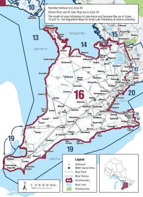
Zone 16
Season Start Date
Season End Date
Sport Limit
2
Conservation Limit
1
Total daily catch and possession limit for all trout, salmon and splake species combined
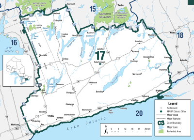
Zone 17
Season Start Date
Season End Date
Sport Limit
3
Conservation Limit
1
Total daily catch and possession limit for all trout, salmon and splake species combined
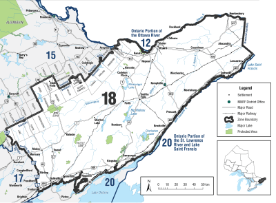
Zone 18
Season Start Date
Season End Date
Sport Limit
2
Conservation Limit
1
Total daily catch and possession limit for all trout, salmon and splake species combined
Additional Fishing Opportunities
Season Start Date
Season End Date
Sport Limit
2
Conservation Limit
1
Additional fishing opportunities
- Ashden Lake (Ashby White Lake) (45°08′59″N., 77°22′00″W.) - Ashby Township
- Big Ohlmann (45°03′18″N., 77°00′23″W.) - Miller Township
- Camp Lake (45°04′54″N., 76°57′39″W.) - Miller Township
- Freen Lake (44°45′25″N., 77°44′53″W.) - Lake Township
- Grimsthorpe Lake (44°52′29″N., 77°23′29″W.) - Effingham Township
- Hungry Lake (44°48′23″N., 76°53′18″W.) - Central Frontenac Township
- Little Green Lake (44°57′37″N., 76°53′06″W.) - Clarendon Township
- Long Mallory Lake (44°59′59″N., 77°09′48″W.) - Abinger Township
- Long Schooner Lake (45°06′15″N., 76°58′41″W.) - Miller Township
- Loughborough Lake (44°27′00″N., 76°25′00″W.) - Pittsburgh Township
- Mackie Lake (45°04′38″N., 76°59′18″W.) - Miller Township
- Potspoon Lake (44°36′13″N., 76°34′56″W.) - Bedford Township
- Redhorse Lake (44°32′21″N., 76°05′02″W.) - Lansdowne Township
- Reid Lake (45°04′15″N., 76°55′59″W.) - Miller Township
- Round Schooner Lake (45°07′12″N., 76°59′14″W.) - Miller Township
- Shabomeka Lake (44°53′33″N., 77°08′10″W.) - Barrie Township
- Silver Lake (44°49′48″N., 76°35′46″W.) - Oso Township
- Simpson Lake (45°09′24″N., 77°24′13″W.) - Ashby Township
- Trout Lake (45°08′58″N., 77°26′08″W.) - Ashby Township
Total daily catch and possession limit for all trout, salmon and splake species combined
Zone 19
Season Start Date
Season End Date
Sport Limit
3
Conservation Limit
1
Total daily catch and possession limit for all trout, salmon and splake species combined
Season Start Date
Season End Date
Sport Limit
3
Conservation Limit
1
Total daily catch and possession limit for all trout, salmon and splake species combined
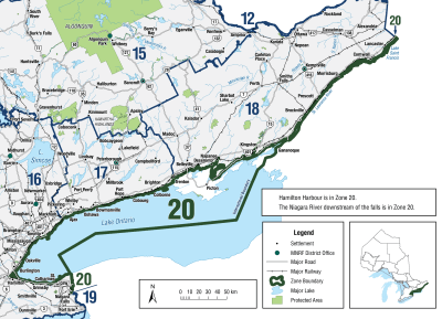
Zone 20
Season Start Date
Season End Date
Sport Limit
3
Conservation Limit
1
Total daily catch and possession limit for all trout, salmon and splake species combined
Season Start Date
Season End Date
Sport Limit
3
Conservation Limit
1
Total daily catch and possession limit for all trout, salmon and splake species combined
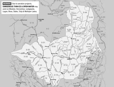
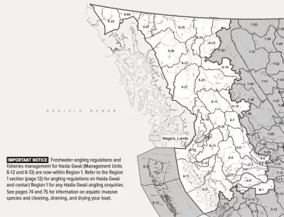
Region 1
Season Start Date
Season End Date
Limit
0
Catch and release only
Total daily catch of 4 for all trout/char species combined
Additional Fishing Opportunities
Season Start Date
Season End Date
Limit
5
Haida Gwaii Daily Quotas
Not more than
- 1 over 50 cm
- 2 from streams
And you must release:
- Trout/char under 30 cm from streams
Total daily catch of 5 for all trout/char species combined
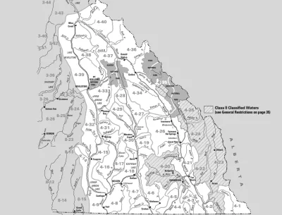
Region 2
Season Start Date
Season End Date
Limit
1
Size must be 60 cm or larger
You must release:
- Wild trout/char from streams
- Hatchery trout/char under 30 cm from streams
Total daily catch of 4 for all trout/char species combined
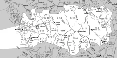
Region 3
Season Start Date
Season End Date
Limit
1
None under 60 cm
And you must release:
- Lake trout, Oct 15 - Jan 31
Total daily catch of 5 for all trout/char species combined
Region 4
Season Start Date
Season End Date
Limit
5
but not more than
- 2 from streams
Total daily catch of 5 for all trout/char species combined
Region 5
Season Start Date
Season End Date
Limit
2
You must release Oct 1 - Nov 30
Total daily catch of 5 for all trout/char species combined
Region 6
Season Start Date
Season End Date
Limit
3
Not more than
- 1 over 50 cm
- 1 from streams Jul 1 - Oct 31
And you must release
- Trout under 30 cm from any stream
- Trout of any size from streams Nov 1 - June 30
- Lake trout from Fraser and Skeena Watersheds Sept 15 - Nov 30
Total daily catch of 5 for all trout/char species combined
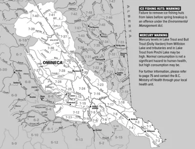
Region 7A
Season Start Date
Season End Date
Limit
3
Not more than
- 1 over 50 cm
- 2 from streams
And you must release:
- of any size, Sept 15-Oct 31
- under 30 cm all year
Total daily catch of 5 for all trout/char species combined
Region 7B
Season Start Date
Season End Date
Limit
2
but not more than
- 1 over 50 cm
- 2 from streams
And you must release:
- Lake trout under 30 cm
- Lake trout of any size, Sept 15-Oct 31
Total daily catch of 5 for all trout/char species combined
Region 8
Season Start Date
Season End Date
Limit
5
but not more than
- 1 over 50 cm
- 4 from streams (only 2 over 30 cm)
Total daily catch of 5 for all trout/char species combined
Copyright © 2026 What To Fish. All Rights Reserved.
Site by Sage
Solutions